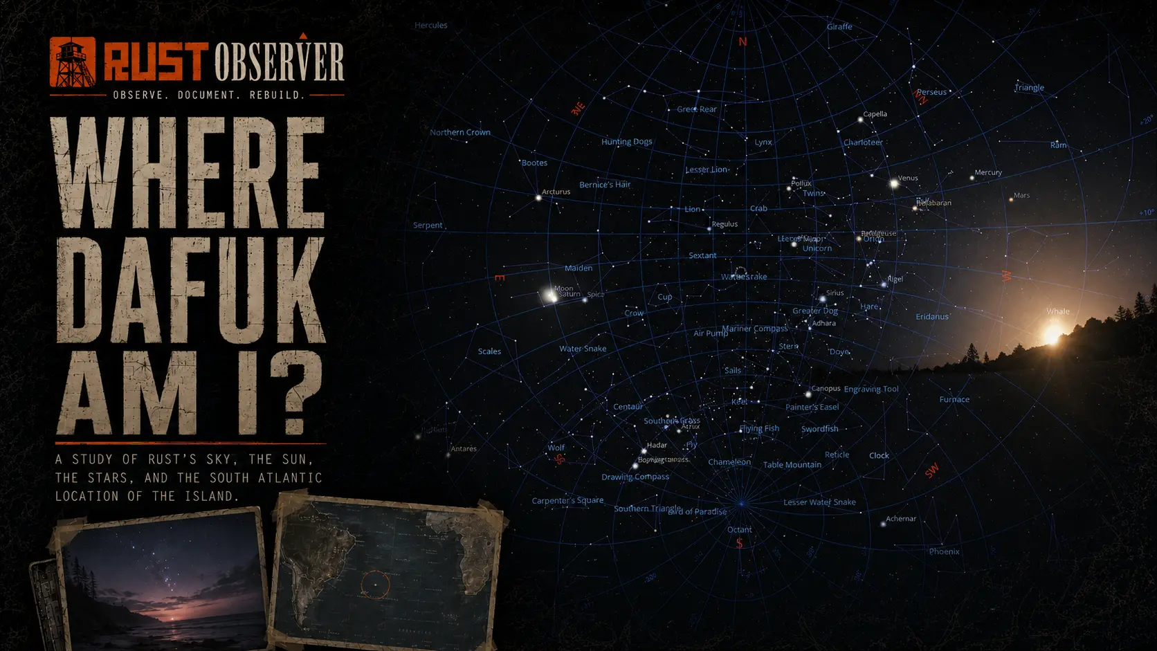
Where Dafuk Am I? #1 — The Astral Connection
Rust’s procedural maps change with every wipe, but the sky remains fixed. By reading the Sun, solving the stars and reconstructing the sky in Stellarium, we traced the island to approximately 10°02′ S, 20°38′ W in the South Atlantic.
“The story begins where everyone’s story begins… naked on a beach with nothing but a rock and a torch.”
— Welyn
But why this beach?
Why not in the middle of the Amazon rainforest, somewhere deep inside the snow, or at the top of a volcano?
We arrive on a temperate shore, surrounded by an island we do not recognize. We may begin gathering wood, searching for cloth or trying to survive the first night before we even think about our position.
Eventually, we open the map.
It shows our location on the generated island. It shows roads, rivers, monuments, coastlines and biomes. It can guide us toward resources, other players or the next objective.
But it cannot answer the larger question:
Does this beach exist somewhere in the real world?
And if it does:
Where is it?
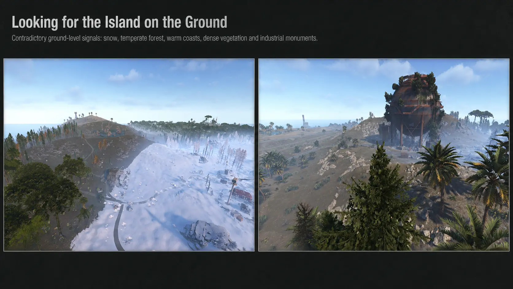
Looking for the Island on the Ground
Several attempts to locate Rust’s island began by comparing its visible features with real places.
At first, that seems reasonable.
The island contains roads, industrial complexes, military structures, forests, deserts, snow, rivers, cliffs and beaches. Perhaps one real island contains the same combination.
But the development history of Rust makes that approach unreliable.
The monuments were not designed together as parts of one coherent geographic location. They were added one after another, over many years, for different gameplay purposes and from different sources of inspiration.
A building may resemble a structure from one country. A vehicle may point toward another period or another continent. Industrial equipment, military facilities and civilian infrastructure can provide clues that contradict each other completely.
Those details can help us identify the inspiration behind an individual object.
They cannot reliably identify the island.
The biomes cannot solve the problem either.
One of Rust’s documented goals has been to place a wide range of terrestrial environments into the same generated world. Temperate forests, deserts, snowfields, wetlands, beaches and rocky terrain can all exist on one island because the purpose is to provide environmental variety.
The same problem applies to the plants, animals and climate.
They create recognizable environments, but their combination does not represent one natural ecosystem.
The coastlines also change from one procedural map to another. Even when a map resembles a real island, the next wipe can produce a completely different shape.
The generated ground therefore cannot be matched reliably with one existing location.
One part of the world was different.
Facepunch had explicitly identified it as being based on reality:
the sky.
The ground was procedural.
The constellations were real.
So, to locate the island, we stopped looking at the island.
A Brief Timeline of the Sky Machine
Rust’s sky was not created in one step. It evolved from the simple skies of Legacy into a synchronized celestial and atmospheric system.
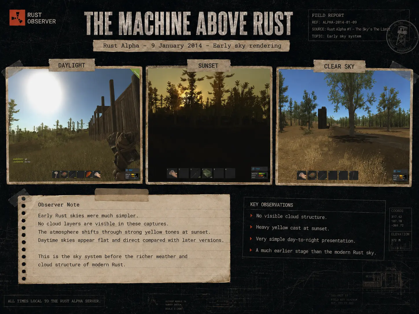
Visual Prologue — Legacy and Experimental, 2014
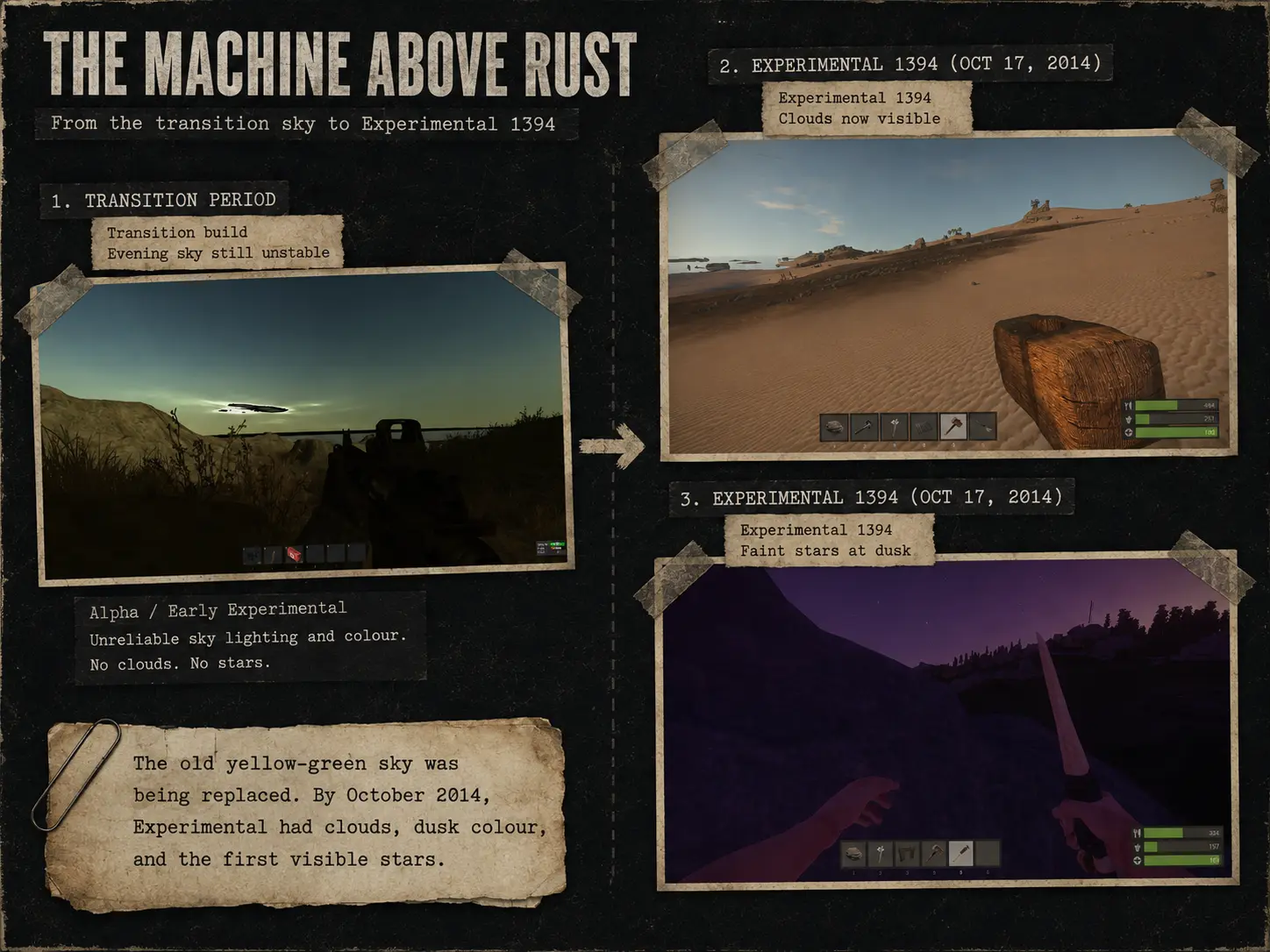
Legacy had a basic blue-and-yellow sky with little visible structure. During the transition to Experimental, the system was sometimes unstable, but by October 2014 clouds, more convincing twilight colours and faint stars were already visible.
25 February 2014 — New Sky
Facepunch replaced the old performance-heavy sky, moved to single-camera rendering and connected night brightness to the lunar cycle. (Rust)
27 June 2014 — Stars and Synchronized Time
Stars became larger and brighter, while server time was synchronized so every player observed the same time of day. (Rust)
16 April 2015 — Real Constellations
Real constellations were added, making navigation by the night sky theoretically possible, alongside an early replacement for the cloud system. (Rust)
30 April 2015 — Horizon and Twilight Clouds
The semi-volumetric clouds received improved shapes, shading and translucency, particularly around sunrise, sunset and the horizon. (Rust)
25 June 2015 — Dynamic Weather
Humidity, precipitation, wind, fog and cloud coverage could now depend on the seed, biome, time and complete date. (Rust)
3 July 2015 — Celestial Visibility
The Moon and stars were adjusted for better visibility, while weather controls became more precise.
3 September 2015 — Reflections and Synchronization
The Sun, Moon, stars and clouds entered the reflection system, and client-server movement of the Sun and Moon was smoothed. (Rust)
26 November 2015 — Layered Clouds
Clouds were divided into high, middle and low layers, allowing different forms, scales and movement speeds.
1 June 2017 — Moon Phases
The dynamic lunar cycle returned, allowing nights to vary from relatively bright to extremely dark. (Rust)
11 January 2018 — Restored Night Sky
Stars became visible again, midnight was darkened and clear weather lost much of its permanent washed-out haze. (Rust)
5 November 2020 — Weather Rebuilt
The old weather system was replaced by artist-designed presets with separate controls for precipitation, fog, atmospheric light and clouds. (Rust)
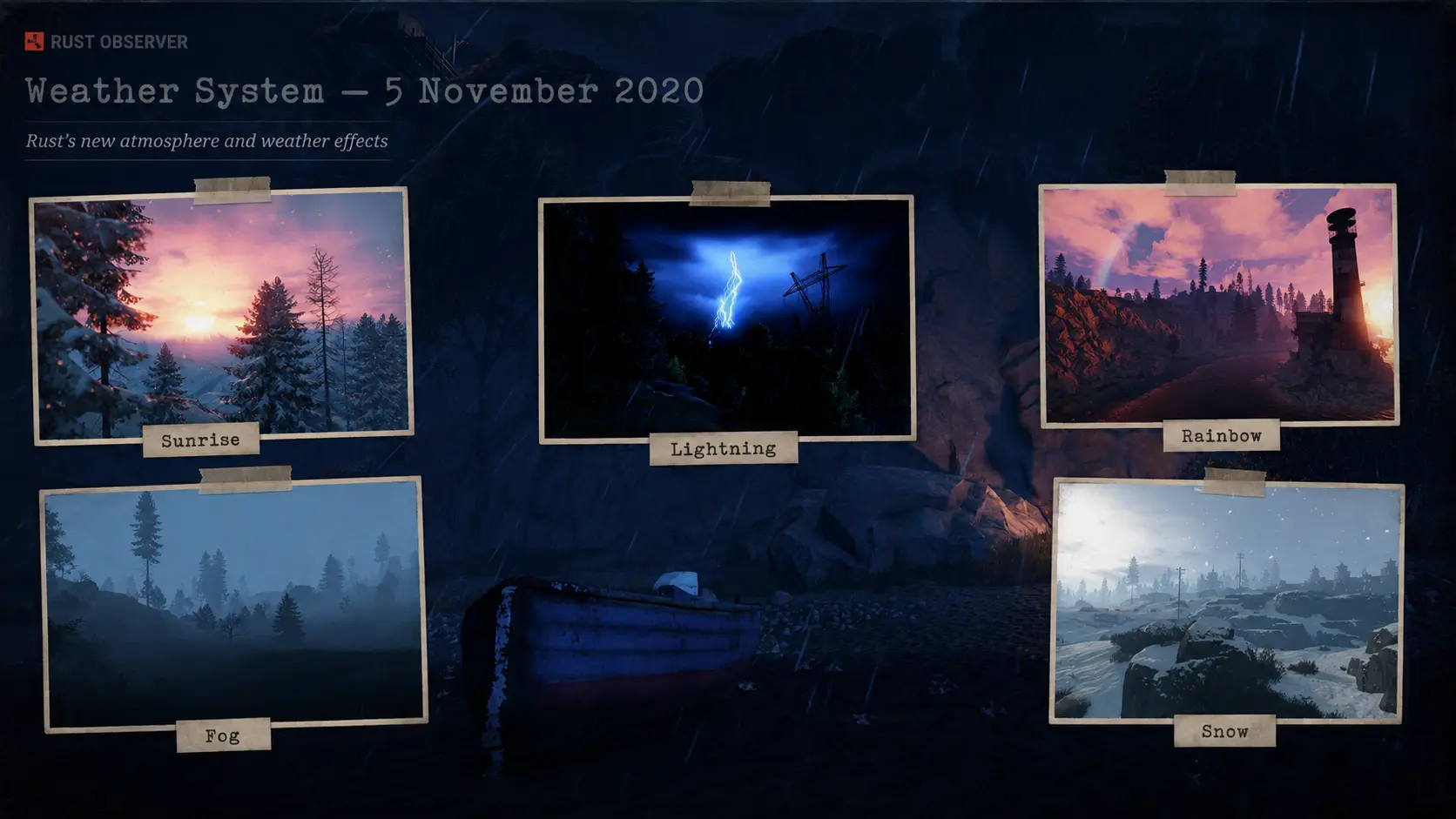
7 August 2025 — Volumetric Atmosphere
Fully three-dimensional clouds and biome-localized volumetric fog brought moving cloud forms, natural lighting, shadows and visible sun rays. (Rust)
5 March 2026 — Extended Daylight
The daylight portion of each Rust day was extended by approximately twenty real minutes, while night remained near ten minutes. (Rust)
More Than a Background
simple sky → synchronized stars → real constellations → dynamic weather → lunar phases → rebuilt atmosphere → volumetric clouds
Facepunch documented how this machine was built.
What they never documented was the place on Earth represented by it.
Players Came to Survive
Most players do not buy Rust to study astronomy.
Rust attracts people because it is a survival game. They come to gather resources, build bases, fight, raid, explore monuments and survive other players.
The stars are part of the atmosphere, like the wind, fog and sound of the ocean. Nothing in the normal gameplay loop requires us to understand them.
The map already provides direction.
A player does not need to locate south from the stars before leaving the beach. A boat does not need to be navigated with Orion. No latitude is required to find the nearest monument.
The sky can therefore remain unnoticed for thousands of hours.
That does not make it meaningless.
It means that a system precise enough to help locate the island had been visible for years above players who had no practical reason to study it.
A Question Without a Complete Answer
This was not a search for a hidden secret.
It was an attempt to answer a question that has followed Rust for much of its existence:
Where is the island?
Players had already asked the question in 2015, 2018 and at other moments in the game’s history.
Some examined the constellations. Others tried to identify the island from its terrain, monuments or climate. A southern location was suspected, particularly because Polaris was absent from the northern sky.
But no complete and reproducible position emerged.
Those early attempts were also made before conversational artificial intelligence became a practical research tool.
The astronomical software already existed. The old development logs already existed. Plate solving, celestial catalogues and scientific image formats already existed.
The difficult part was knowing which tools could answer each part of the question and how their results should be connected.
We began with the simplest instrument available.
A Pole, a Shadow and the Sun
Place a straight pole in the ground and observe its shadow.
The shadow is long in the morning. It becomes shorter as the Sun rises, reaches its minimum when the Sun is at its highest point, then grows again during the afternoon.
The shortest shadow identifies approximate solar noon.
An ordinary player could perform this observation over many game days.
Administrative controls allowed us to move through Rust’s native calendar more quickly. They did not reposition the Sun or create a different sky. They only avoided waiting through weeks of accelerated game time between observations.
We recorded the approximate time of the shortest shadow on several dates:
| Date | Approximate solar noon |
|---|---|
| 11 February | 13:12 |
| 25 March | 13:06 |
| 28 March | 14:06 |
| 21 June | 14:00 |
| 26 July | 14:06 |
| 18 October | 13:42 |
| 28 October | 13:42 |
| 29 October | 12:42 |
| 21 December | 12:54 |
The displayed time of solar noon was not permanently fixed.
The one-hour change between 25 and 28 March, followed by the opposite change between 28 and 29 October, matched the seasonal clock changes used in the United Kingdom.
That is a logical convention for the calendar used by the Rust development team, based in Birmingham, UK.
This identifies the civil-time system followed by Rust’s clock. It does not place the island in the United Kingdom.
The most useful observation occurred in October.
At approximately 13:30, the Sun passed almost directly above the vertical reference. The shadow became nearly invisible beneath it.
That is a solar zenith.
On Earth, the Sun can pass directly overhead only between the tropics. The date of the passage indicates the Sun’s declination and therefore the approximate latitude of the observer.
The first result placed the island near:
9.4 to 10 degrees south
One pole had reduced the search from half the planet to a narrow band around it.
The Sun could give us latitude.
The stars would have to provide the rest.
Weather and the Complete Calendar
The weather preset did not control the entire appearance of the sky.
Repeated observations showed two overlapping parts.
The first was a background atmosphere linked to the complete date and hour. It produced a reproducible atmospheric portrait, including days that appeared brighter, darker or hazier even while the weather preset remained on Clear.
The second was a surface weather layer. Presets, seeds, biomes and local regions added rain, fog, low clouds, heat and temporary showers over that dated background.
This was important because it showed that Rust was not simply replaying one decorative sky every day.
The complete date affected what appeared above the island.
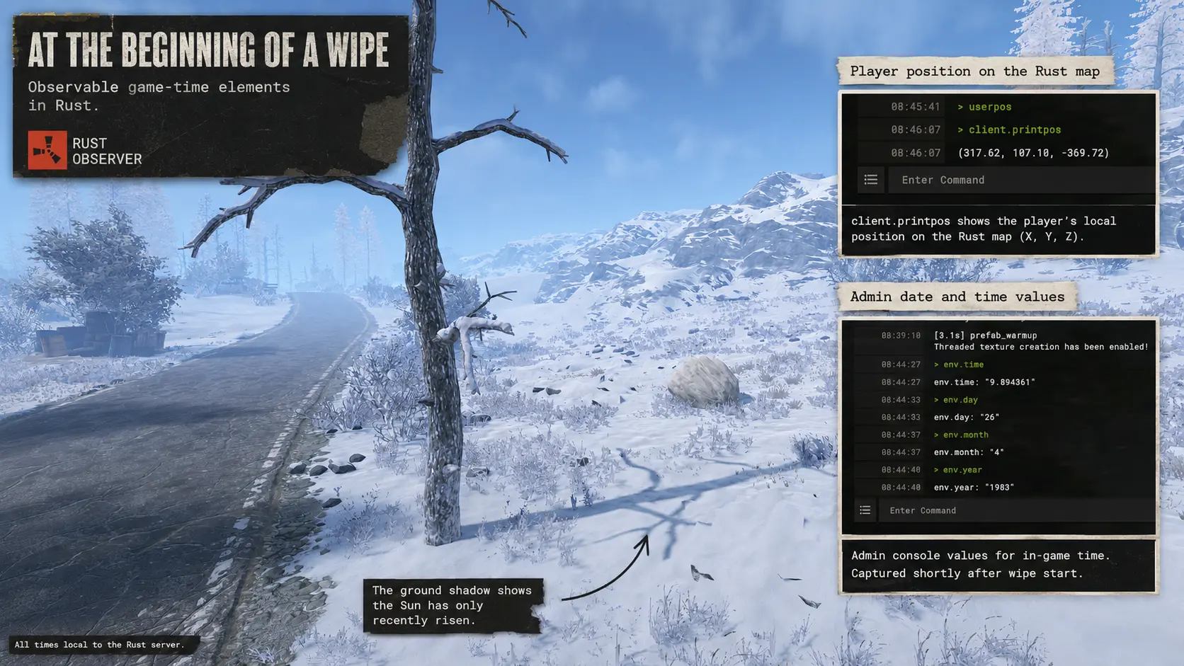
The First Day of the World
A fresh Rust world begins on:
26 April 1983 at 09:00
Players may first enter later because the game clock continues advancing while the server completes the wipe and loads the new world.
On a regular server, that process can take approximately ten minutes. Since a complete Rust day lasts about eighty real minutes, roughly three in-game hours may already have passed before the server becomes accessible.
The world still begins at 09:00. The difference comes from how much of that first day has passed during the loading process.
For the stellar observation, we selected:
26 April 1983 at 20:00
The choice was practical.
In Rust, the Sun had already passed below the western horizon, but the sky still retained a faint trace of twilight. The stars were visible, while the western horizon preserved a slight pink glow.
That gave us both the celestial patterns and a directional reference.
Photographing the Skydome
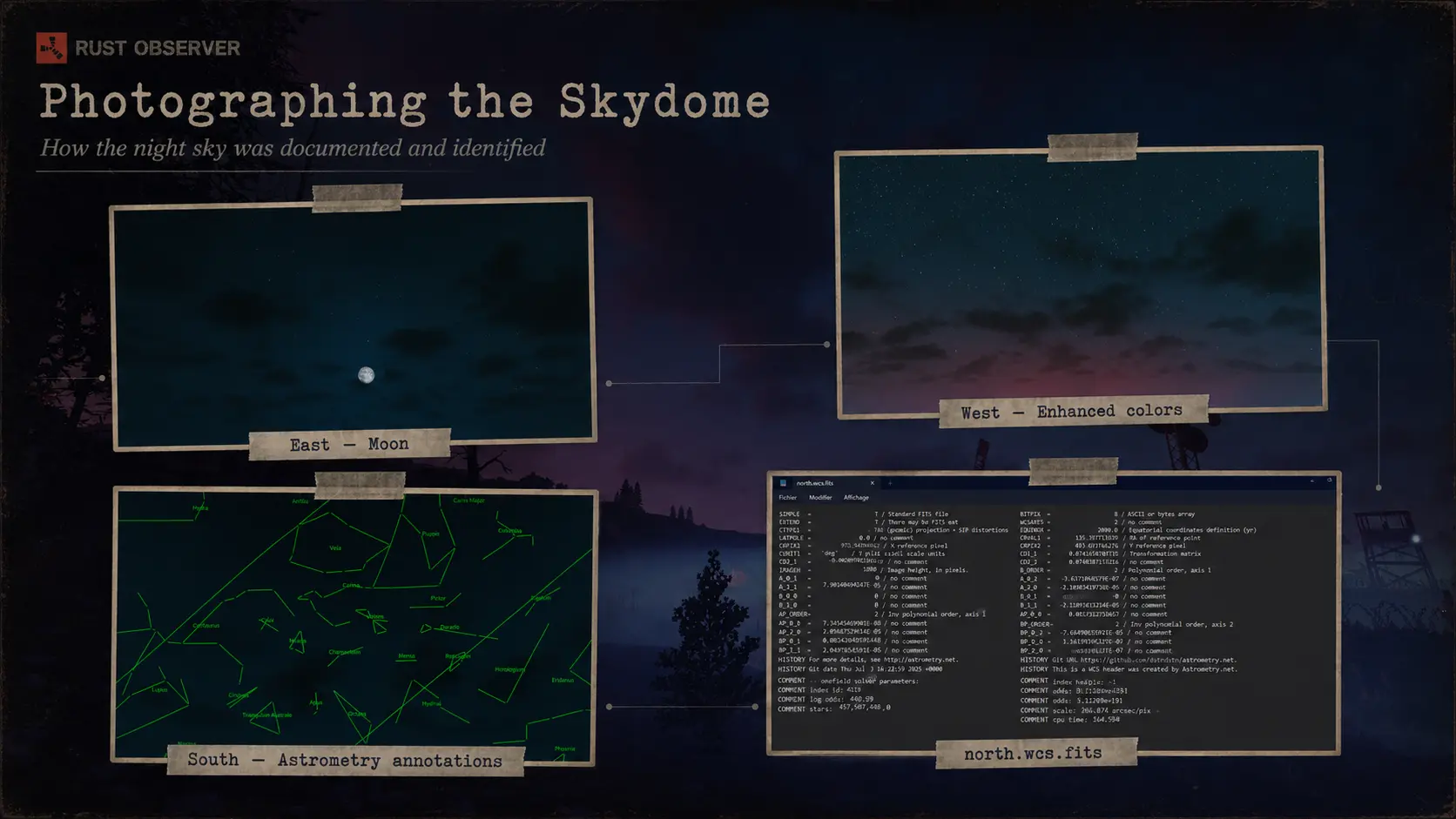
We took four screenshots from the beach at horizon level:
- north;
- south;
- east;
- west.
A fifth screenshot covered the sky toward the south and zenith.
The captures used a field of view of approximately 75 degrees. Wider tests produced more distortion near the edges and made the stars more difficult to identify.
Each useful capture was preserved in several forms:
- the original screenshot;
- a contrast-adjusted version;
- an annotated astronomical solution;
- and the associated scientific files.
Increasing the contrast revealed stars already present in the image. It did not add or move them.
The screenshots came from fresh vanilla worlds. No plugin altered the position of the Sun, Moon or stars.
Astrometry.net
The screenshots were submitted separately to Astrometry.net.
Astrometry.net performs a process known as plate solving.
It examines the geometric relationships between stars in an image and compares those patterns with astronomical catalogues. It can identify which part of the real sky appears in the image without being told which constellation it should find.
We did not provide the service with the location of the island.
We submitted the stars produced by Rust.
For each successful solution, Astrometry.net returned an annotated image identifying the celestial regions contained in the capture.
It also produced FITS and WCS files.
What the FITS Files Told Us
FITS stands for Flexible Image Transport System.
It is a scientific format used in astronomy to preserve images and the technical information required to interpret them.
The associated World Coordinate System connected positions in the screenshot with positions on the celestial sphere.
The files contained information such as:
- the celestial coordinates at the centre of the image;
- the image orientation;
- the field of view;
- the pixel scale;
- and the position of the detected stars.
The principal celestial coordinates were right ascension and declination.
They identify where the camera was pointing in the sky.
They do not directly identify where the camera was standing on Earth.
To locate the observer, those celestial coordinates still had to be connected with the date, hour, visible horizon and cardinal viewing directions.
Four Directions, One Sky
The captures produced coherent celestial solutions.
The southern image matched the southern sky.
The northern image matched the northern sky.
The eastern image matched the east.
The western image matched the west.
Their orientation within the screenshots differed:
| Rust view | Identified sky | Image rotation |
|---|---|---|
| South | South | 0° |
| North | North | 180° |
| West | West | +90° |
| East | East | −90° |
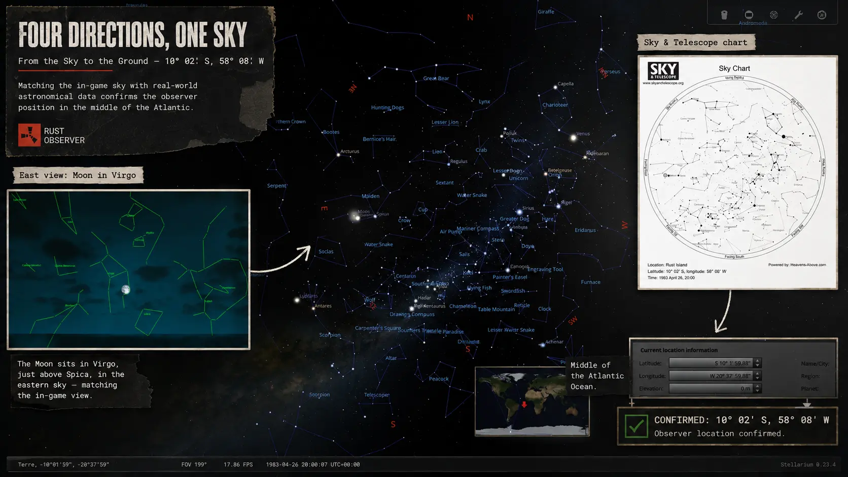
Once the images were interpreted according to their viewing directions, the constellations occupied their expected sectors.
The fifth capture, aimed toward the south and zenith, aligned with the celestial regions already identified from the horizon images.
These were not unrelated decorative backgrounds.
They belonged to one coherent skydome.
From the Sky to the Ground
The solar observation had already placed the observer close to 10 degrees south.
The astrometric solutions supplied the celestial fields visible in each direction.
We then combined:
- the date;
- the hour;
- the horizon;
- the four cardinal directions;
- the solar latitude;
- and the solved star fields.
A valid terrestrial location had to reproduce all of the captures at the same time.
Finding Orion somewhere in the sky was not sufficient.
Orion had to appear in the correct western sector. The Moon and the constellations visible in the eastern image had to appear in the east. The northern and southern fields had to occupy their respective horizons during the same observation.
The resulting position was approximately:
10°02′ S, 20°38′ W
In decimal form:
−10.0333, −20.6333
The minutes should not be interpreted as survey-grade GPS accuracy. Rust does not render every catalogue star, the screenshots were aligned manually and the skydome was created for a video game.
The stable result was the region:
approximately 10° south and 20–21° west
Testing the Result in Reverse
Astrometry.net had worked from Rust’s screenshots toward the celestial sphere.
The next step was to reverse the experiment.
Stellarium can reconstruct the visible sky for a selected terrestrial location, date and time.
We entered the proposed coordinates and recreated the sky for:
26 April 1983 at 20:00
We then compared the same cardinal sectors.
The arrangement matched.
The Moon occupied the eastern side of the sky.
Orion appeared toward the west.
The surrounding constellations appeared in the expected regions.
The Sun sat just below the western horizon, explaining the faint pink light still visible beneath the stars in the Rust screenshot.
The test now worked in both directions.
Rust’s screenshots identified the celestial fields.
The proposed geographic location reconstructed Rust’s sky.
Three Servers, Three Wipes
The complete observation was repeated on three separate vanilla servers and fresh wipes.
The seeds changed.
The coastlines changed.
The maps changed.
The celestial position did not.
The results returned to the same region within only a few hundredths of a degree.
The location was therefore not based on recognizing one constellation and guessing where it belonged.
It came from:
- a solar latitude;
- five connected sky captures;
- four known directions;
- plate-solving results;
- the Rust calendar;
- an independent Stellarium reconstruction;
- and repeated tests on different worlds.
Dropping the Coordinates into a Map
The coordinates were entered into Google Maps:
−10.0333, −20.6333
The marker landed in the open South Atlantic Ocean, between South America and Africa.
No continent appeared beneath it.
No coastline crossed the point.
No named island occupied the coordinates.
The astronomical result matched the situation in which every Rust player begins:
an unknown island surrounded by ocean.
Looking Below the Surface
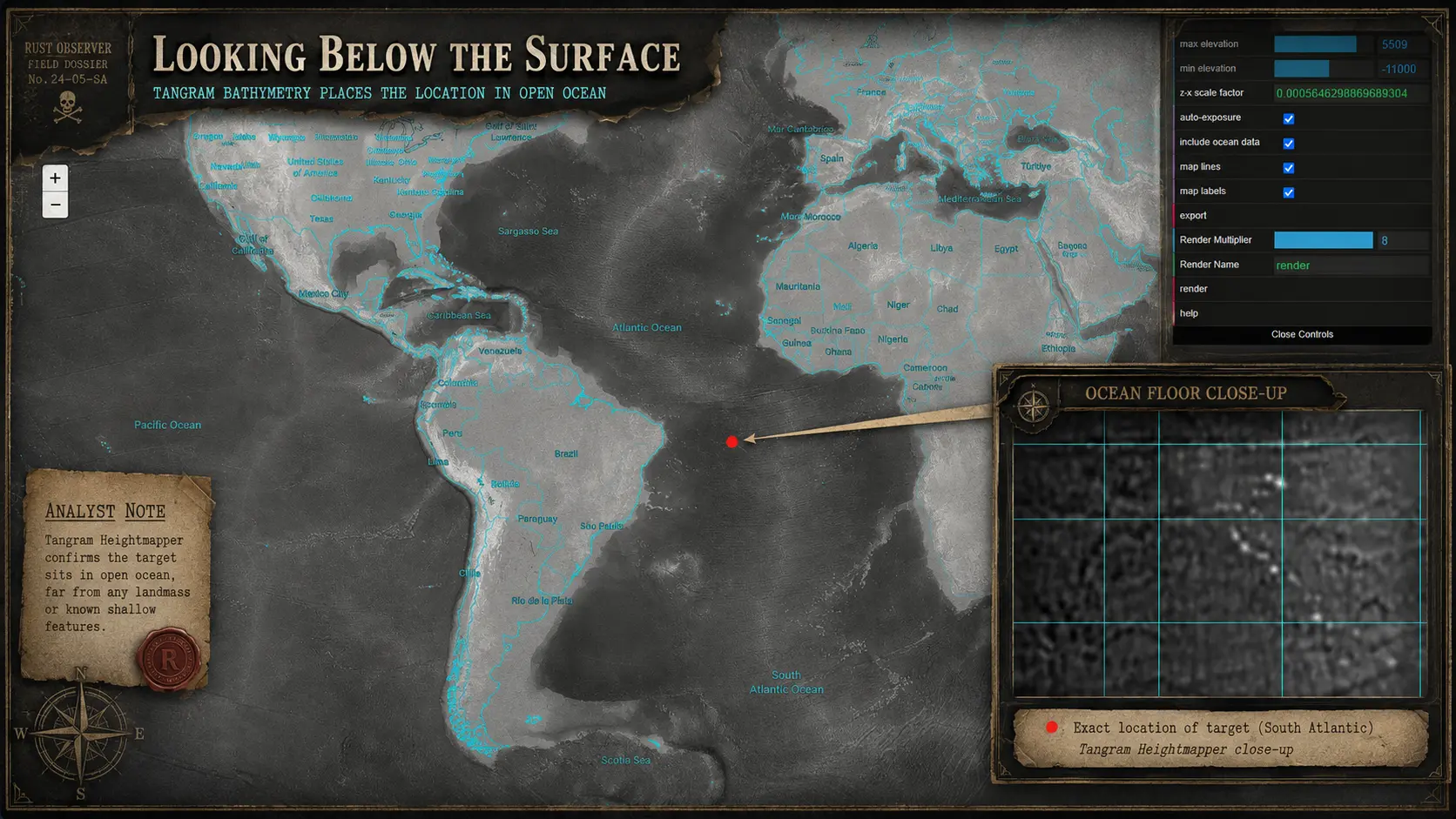
A surface map can show that no land is visible, but it cannot show whether a shallow platform or submerged mountain exists immediately beneath the point.
The coordinates were therefore examined in a bathymetric heightmap viewer with ocean data enabled.
At the selected zoom level, the visible sector ranged from approximately:
- −619 metres at its highest displayed relief;
- to −6,181 metres at its deepest.
Those values described the complete visible window, not the depth of one exact central pixel.
The broader result was nevertheless clear.
There was no emergent land and no shallow island platform visible around the inferred position.
The coordinates fell over deep ocean.
Rust’s generated island is not a direct model of a real island occupying that point.
The coastline belongs to Rust.
The position beneath the sky belongs to Earth.
How This Investigation Was Done
Finding the real-world inspiration for an object in Rust can sometimes be straightforward.
A photograph of a bus stop, an industrial tank or a piece of machinery may provide an immediate visual correspondence. The object can be compared with the game model, and the resemblance can be explained directly.
Locating the island from its sky required a different kind of research.
No single screenshot, website or software package contained the answer.
The investigation had to move between the history of Rust’s development, server administration, solar observation, celestial navigation, image processing, plate solving, FITS files, astronomical software, geographic maps and ocean bathymetry.
Each method answered only one part of the question.
The development logs established that the constellations were real.
The Sun narrowed the latitude.
The screenshots preserved the cardinal sky.
Astrometry.net identified the celestial fields.
The FITS files preserved their coordinates and orientation.
Stellarium tested whether a terrestrial location could reproduce the same sky.
Fresh servers and wipes tested whether the result was stable.
Maps and bathymetric data showed what occupied the final coordinates in the real world.
Artificial intelligence did not look at one Rust screenshot and provide the answer.
It allowed several possible methods to be examined, technical information from the FITS files to be concentrated, interpretations to be debated and specialized documentation to be found much more quickly than through manual research alone.
Stellarium provides a practical example.
The software was already publicly available. But having access to an astronomical program is not the same as knowing how to use it for one specific investigation.
Without guidance, learning how to create a custom location, set the correct date and time, control the horizon, orient the view and identify which elements mattered could have required hours of manuals, FAQs and trial and error.
With direct AI assistance, the useful controls could be understood within minutes.
The final comparison still had to be performed manually. The location still had to be entered. The view still had to be oriented. The Moon, Orion, surrounding constellations and remaining western twilight still had to be compared with Rust.
AI accelerated the movement between the question and the methods needed to test it.
It did not replace the observations.
Earlier players had the same sky and many of the same tools. What they did not have was the same practical ability to move rapidly between unrelated fields of specialized knowledge.
That helps explain why a question posed years ago could remain unanswered even though the evidence had always been visible above the island.
So, Where Dafuk Am I?
The monuments could not locate the island because they were added independently and pointed toward different places.
The biomes could not locate it because they were designed to represent a broad range of environments in the same generated world.
The coastline could not locate it because it changed with every procedural map.
The sky was different.
Its constellations were real.
Its Sun followed a calendar.
Its celestial fields could be identified, reconstructed and tested.
The Sun first placed the observer near 10 degrees south.
The stars supplied the remaining position.
Stellarium reconstructed the same celestial arrangement.
Three servers and three fresh wipes returned the same region.
Google Maps placed the result in the open South Atlantic, and the bathymetry showed deep ocean beneath it.
The final position was approximately:
10°02′ S, 20°38′ W
The map tells us where we are standing on the island.
The sky tells us where the island is standing on Earth.
Now we know.
Opening quotation credit
Opening quotation by Welyn, with permission: https://www.youtube.com/@Welyn
References
Rust and Facepunch development logs
These official sources detail the construction of Rust’s sky, stars, clouds, weather, lunar phases, and time synchronization. (Rust)
- Facepunch Studios. 25th February Update. 25 February 2014.
Replacement of the old sky and connection between lunar cycles and night brightness. - Facepunch Studios. Friday Devblog 14. 27 June 2014.
Larger and brighter stars; network-synchronized time of day. - Facepunch Studios. Devblog 56. 16 April 2015.
Real constellations, possible navigation by the night sky and early cloud-system work. - Facepunch Studios. Devblog 58. 30 April 2015.
Semi-volumetric cloud layers, horizon clouds and sunrise/sunset translucency. - Facepunch Studios. Devblog 66. 25 June 2015.
Dynamic weather based on humidity, precipitation, wind, fog, clouds, biome, seed, time and date. - Facepunch Studios. Devblog 67. 3 July 2015.
Increased Moon and star brightness and more precise weather controls. - Facepunch Studios. Devblog 76. 3 September 2015.
Sun, Moon, stars and clouds added to environmental reflections; smoother client-server time synchronization. - Facepunch Studios. Devblog 88. 26 November 2015.
High, middle and low cloud layers, with different forms, scales and movement speeds. - Facepunch Studios. Devblog 92. 7 January 2016.
Stronger fog effects and increased cloud and atmospheric fog during rain. - Facepunch Studios. Devblog 162. 1 June 2017.
Restoration of the dynamic lunar phase cycle. - Facepunch Studios. Devblog 193. 11 January 2018.
Gradual fog, reduced clear-sky haze, restored stars and darker midnight skies. - Facepunch Studios. Stables Update. 5 November 2020.
Rebuilt weather system with artist-designed presets and separate atmospheric controls. - Facepunch Studios. World Revamp. 6 May 2021.
Major visual overhaul of terrain, vegetation, rocks and monuments. - Facepunch Studios. Solid Foundations. 5 October 2023.
Increased probability of rain, storms and fog. - Facepunch Studios. Harder Core. 7 August 2025.
Fully volumetric clouds and biome-localized volumetric fog. - Facepunch Studios. Shipshape. 5 March 2026.
Extended daylight while retaining approximately ten-minute nights.
Astronomy and plate solving
Astrometry.net identifies an image’s celestial pointing, scale and orientation without requiring an initial location estimate. The paper and official project bibliography document the plate-solving method used in the investigation. (Astrometry)
- Lang, Dustin; Hogg, David W.; Mierle, Keir; Blanton, Michael; Roweis, Sam. Astrometry.net: Blind Astrometric Calibration of Arbitrary Astronomical Images. The Astronomical Journal, 2010.
- Astrometry.net
Plate-solving service used for the Rust sky captures. - Astrometry.net Bibliography
FITS and WCS files
FITS is the standard astronomical data format maintained through NASA’s FITS Support Office. The WCS information connects image pixels with positions on the celestial sphere. (FITS Support Office)
- NASA Goddard Space Flight Center. FITS Support Office
- NASA Goddard Space Flight Center. FITS Standard and Documentation
Sky reconstruction
Stellarium reconstructs the visible sky according to the observer’s location, date and time, making it suitable for testing the proposed coordinates in reverse. (Stellarium)
Geographic and bathymetric verification
Original observations and research material
All Rust screenshots, server-calendar readings, shadow observations, cardinal sky captures, contrast-enhanced images, Astrometry.net solutions, FITS/WCS files and repeated vanilla-wipe tests were produced or collected specifically for this investigation.