
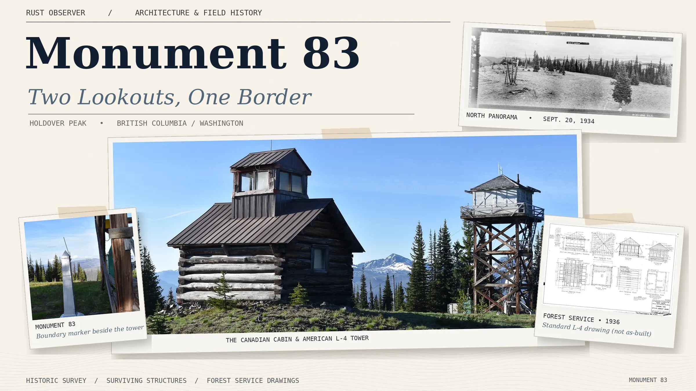
Monument 83: Two Lookouts, One Border
At Monument 83, an American fire lookout cabin stands in Canada while its successor rises just across the border in Washington. Archival photographs, original L-4 blueprints, forgotten observers, the mystery of Pasayten Pete, and recent wildfires reveal a century of history on Holdover Peak—and an extraordinary subject for reconstruction in Rust.
Three generations of fire detection, an international boundary, and the people and instruments that watched the wilderness.
At the summit of Holdover Peak, approximately 6,520 feet (1,987 metres) above sea level, a small collection of wooden structures tells an unusually complete story of North American forest-fire observation.
A log cabin with a glass-walled observation cupola stands on Canadian soil. Immediately south, an elevated timber tower carries an American L-4 lookout cab. Between them, the international boundary runs past Monument 83, the border marker that gives this remarkable place its name.
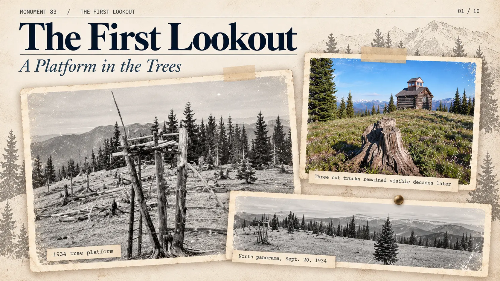
The two buildings represent successive generations of fire detection. They are not the beginning of the story. Three cut tree trunks nearby mark the remains of an earlier observation platform.
Taken together, the surviving structures offer a rare opportunity to examine the complete operation of a mountain lookout: the reasons for choosing the summit, the buildings designed to make observation possible, the instruments used to locate smoke, the furnishings that protected the operator’s field of view, and the procedures followed when a fire was detected. They also reveal a history of cross-border cooperation, wartime aircraft observation, isolated seasonal work, local folklore, and the modern wildfires that once again threatened the station.
For Rust Observer, Monument 83 is more than an unusual landmark to reproduce. Understanding how it actually worked is the starting point for reconstructing it faithfully in Rust.
1. The First Lookout: A Platform in the Trees
Monument 83 became a fire observation station during the 1920s. Its first lookout was an economical structure assembled directly from the surrounding forest.
Three trees were cut back to serve as uprights for an elevated wooden platform. A ladder provided access. The arrangement used the available timber and offered a raised position without requiring a cabin or a separate framed tower.
An Osborne panoramic photograph taken in 1934 shows that this early platform was still standing after a more substantial lookout cabin had already been built nearby. The image is valuable because it establishes the original construction method. This was a platform supported by three truncated trunks—not a treehouse among living branches.
Photographs published by the British Columbia Ministry of Environment and BC Parks in 2010 show the three surviving stumps, physical traces of the earliest station more than eight decades after its construction.
The first platform answers a fundamental question about the location: before permanent buildings, the operators already valued the mountain’s field of view enough to establish an elevated observation position. The next generation made that position habitable.
2. The Log Cabin of 1930
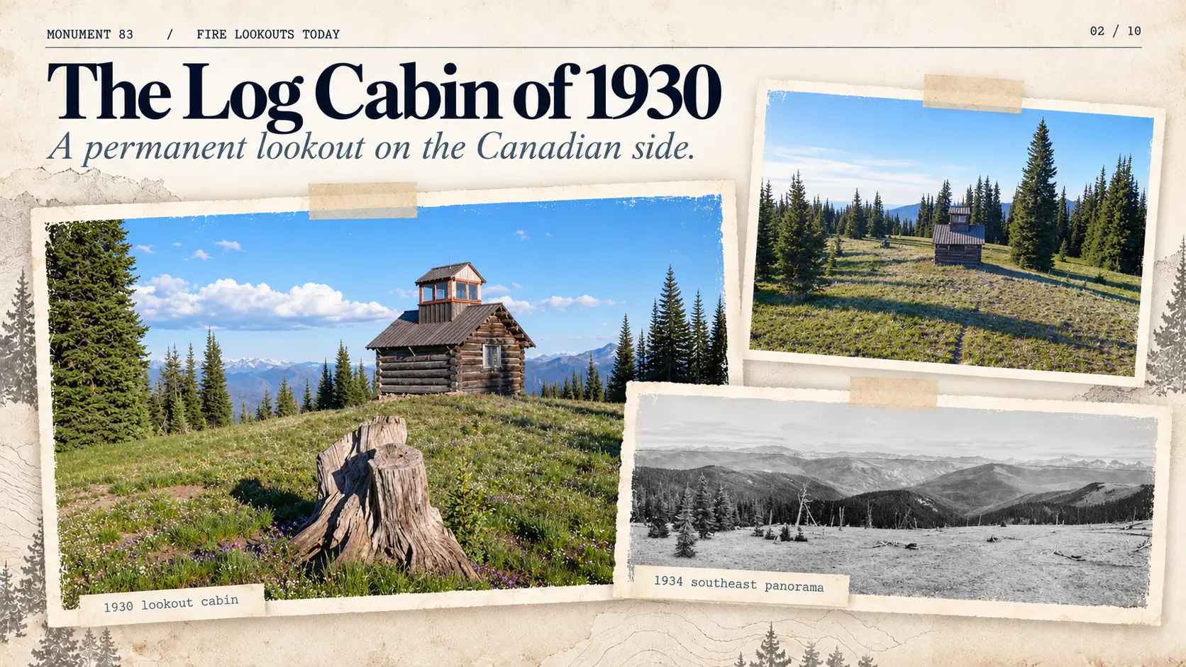
In 1930, a permanent lookout cabin was constructed at Monument 83. The log building measured approximately 14 by 14 feet (4.27 by 4.27 metres), with a much smaller glass-walled observation room measuring 6 by 6 feet (1.83 by 1.83 metres) rising above its main roof.
Sometimes called a cupola or doghouse, this upper room supplied the panoramic view needed to watch for smoke. The lower structure provided shelter, storage, and space for the person assigned to the station. Its crossed-log walls were a familiar form of construction in the forested regions of the Pacific Northwest.
The cabin’s unusual form becomes easier to understand by examining its environment. It was not a thirty-foot lookout tower. The observation cupola stood only a little above the roof, yet it was installed in a place where the surrounding summit offered extensive natural visibility.
The open summit of 1934
On September 20, 1934, three technical panoramic photographs documented the landscape from Monument 83. They show a summit substantially more open than modern photographs might lead visitors to expect.
The northern image records the original three-trunk observation platform amid exposed ground and scattered conifers. The southeastern panorama opens across ridges and distant valleys. The southwestern view is especially revealing: numerous dead standing trees, broken trunks, logs, and areas of sparse vegetation testify to earlier forest disturbance.
The broader Pasayten region experienced major wildfires in the 1920s, including fires documented by researcher George R. Fahnestock in 1926 and 1929. The appearance of the summit is consistent with that history, although the available photographs do not identify the precise fire—or combination of events—that produced every feature seen at Monument 83.
The photographic record explains why a low observation cupola could once be effective. A lookout’s usefulness depends not only on the height of the structure but also on the visibility of the land around it. As trees regenerate, a view that once cleared the forest canopy can gradually disappear behind new growth.
The Canadian Register of Historic Places recognizes the station’s cleared subalpine setting, open views, and deliberately modified vegetation as essential elements of its heritage character. The building and its landscape must therefore be understood together.
These 1934 images are also important technical evidence. They were produced with a specialized measuring camera rather than an ordinary souvenir camera. Their instrument, photographer, and original purpose are examined in Chapter 6.
3. An American Lookout in Canada
The log cabin stands north of the international boundary, in British Columbia, although its duties were associated with the United States Forest Service.
The arrangement is sometimes described as an accidental construction on the wrong side of the border, discovered only much later. A contemporary newspaper report tells a more interesting story.
On October 27, 1937, The Oregonian identified A. C. Mattison as an American Forest Service observer working at Monument 83 on foreign soil. The newspaper reported that the station occupied its Canadian position under a special privilege granted by the British Crown. That original authorization has not yet been located independently, so the report documents what was publicly asserted at the time rather than proving the precise legal instrument.
The newspaper also described an argument about flags. Canadian authorities reportedly objected to an American flag flying from the building on Canadian territory. Mattison requested a British flag but did not receive one. Instead, the Stars and Stripes flew from a pole erected on the American side of the border.
The buildings could remain where they were; the flag belonged on the other side of the line.
The episode is more than a frontier curiosity. It demonstrates that the cabin’s location was recognized while the station was still operating and that the international boundary imposed practical constraints even on the daily routine of fire protection.
The Boundary Vista
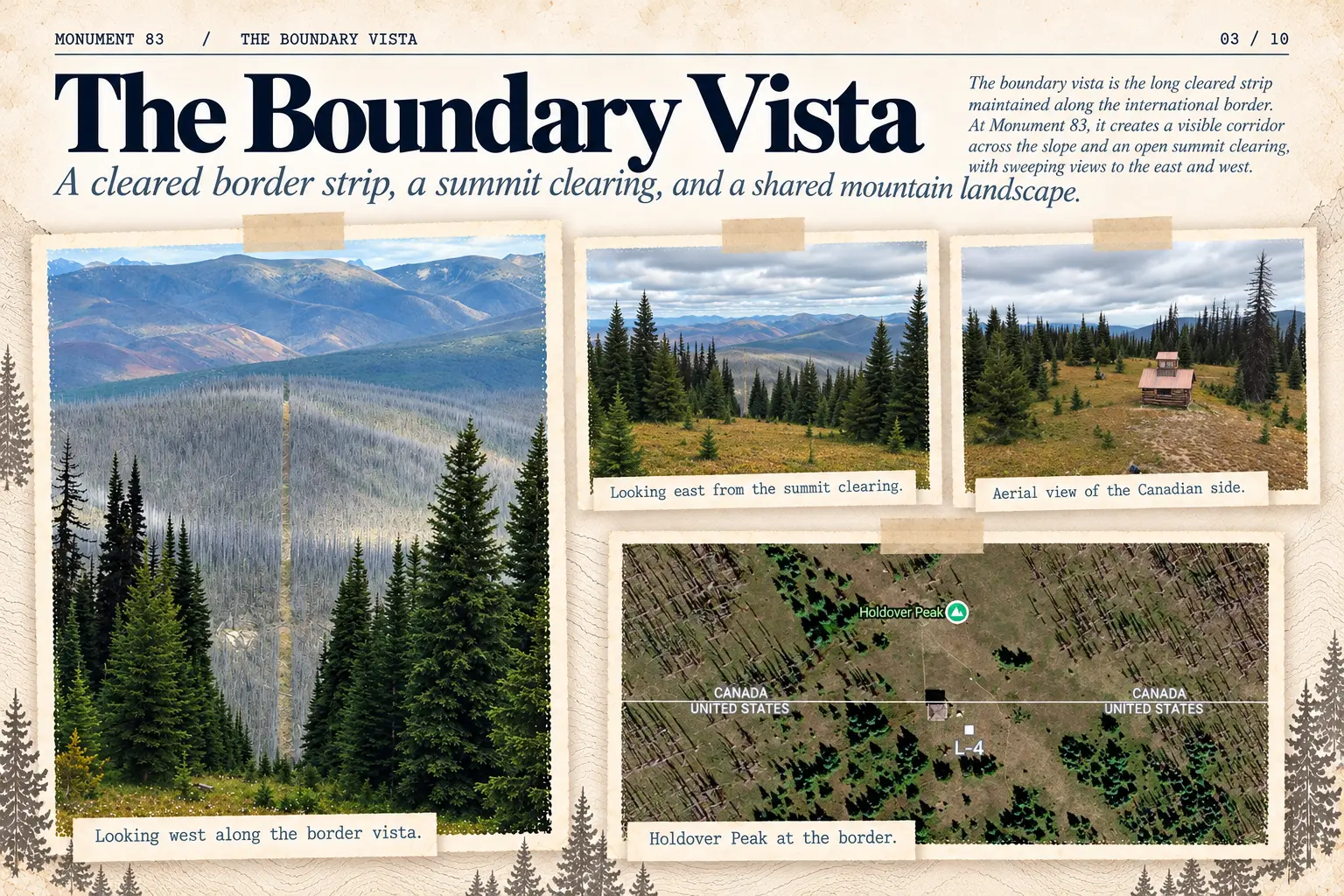
Across forested parts of the Canadian-American boundary, from the Pacific toward the Atlantic, the two countries maintain a cleared corridor known as the boundary vista. According to the International Boundary Commission, its standard width is twenty feet (approximately six metres), extending ten feet on either side of the line.
This narrow strip can be seen continuing in a strikingly straight course across distant wooded slopes. Its appearance changes with weather and season: it may be a pale opening in summer or an almost luminous white line against winter forest.
The broad clearing surrounding the Monument 83 buildings is a different feature. It is much wider than the standard border corridor and reflects the summit’s history of vegetation disturbance, deliberate clearance, and lookout operation.
The boundary vista is therefore the maintained international corridor, not every open part of the mountaintop. At Monument 83, the corridor passes directly through a landscape already modified for forest-fire observation.
4. The L-4: A New Lookout on American Soil
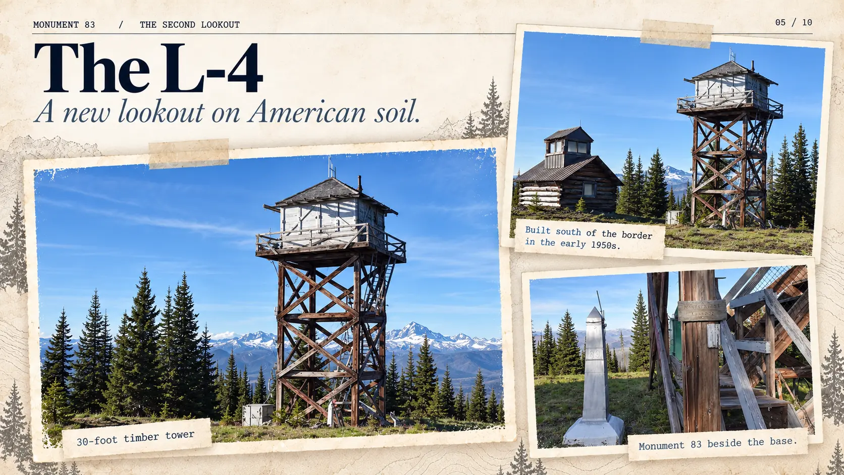
In the early 1950s, the U.S. Forest Service constructed a new station immediately south of the boundary, replacing the low Canadian log cabin as its primary elevated observation position.
The installation consisted of a timber tower approximately thirty feet high, supporting an enclosed L-4 lookout house. Historical references give 1952 or 1953 for construction; lookout inventories commonly identify 1953.
The difference in architecture is unmistakable. Rather than raising a small cupola above a log cabin, the new station elevated an entire observation room on a separate timber framework. Large windows offered views around the cab. Diagonal bracing stabilized the supporting structure, stairs provided access, and a surrounding catwalk let an observer move outside the room.
The tower stands extraordinarily close to Monument 83 itself. The boundary marker is only a short distance from the tower’s base, and the catwalk projects almost to the international line. The exact relationship is best understood from authentic site photographs, not by estimating centimetres from reproductions.
Construction across two countries
A report in the Methow Valley News dated July 1, 1954, describes how Canadian forest personnel helped make the American construction project possible. Materials were brought through Manning Park, stored, and moved toward the summit with assistance from Canadian crews.
The account credits the cooperation with substantial savings. It also describes communication links between the forest services: Canadian radio communication with Monument 83 had been established in the preceding year, while additional telephone arrangements were being considered.
The station was American, its predecessor was physically in Canada, and the surrounding forest did not respect the line between their administrative jurisdictions. Practical cooperation was part of the lookout’s history.
5. The L-4 Blueprints: Engineering a Fire Lookout
By the time Monument 83 received its American timber tower, the Forest Service had developed standardized architectural designs for remote observation stations. Surviving plans allow us to study the construction system without inventing details from exterior photographs.
These drawings do not constitute authenticated as-built plans for Monument 83. They are period engineering references to be compared with the surviving tower.
The L-4 is the house, not the tower
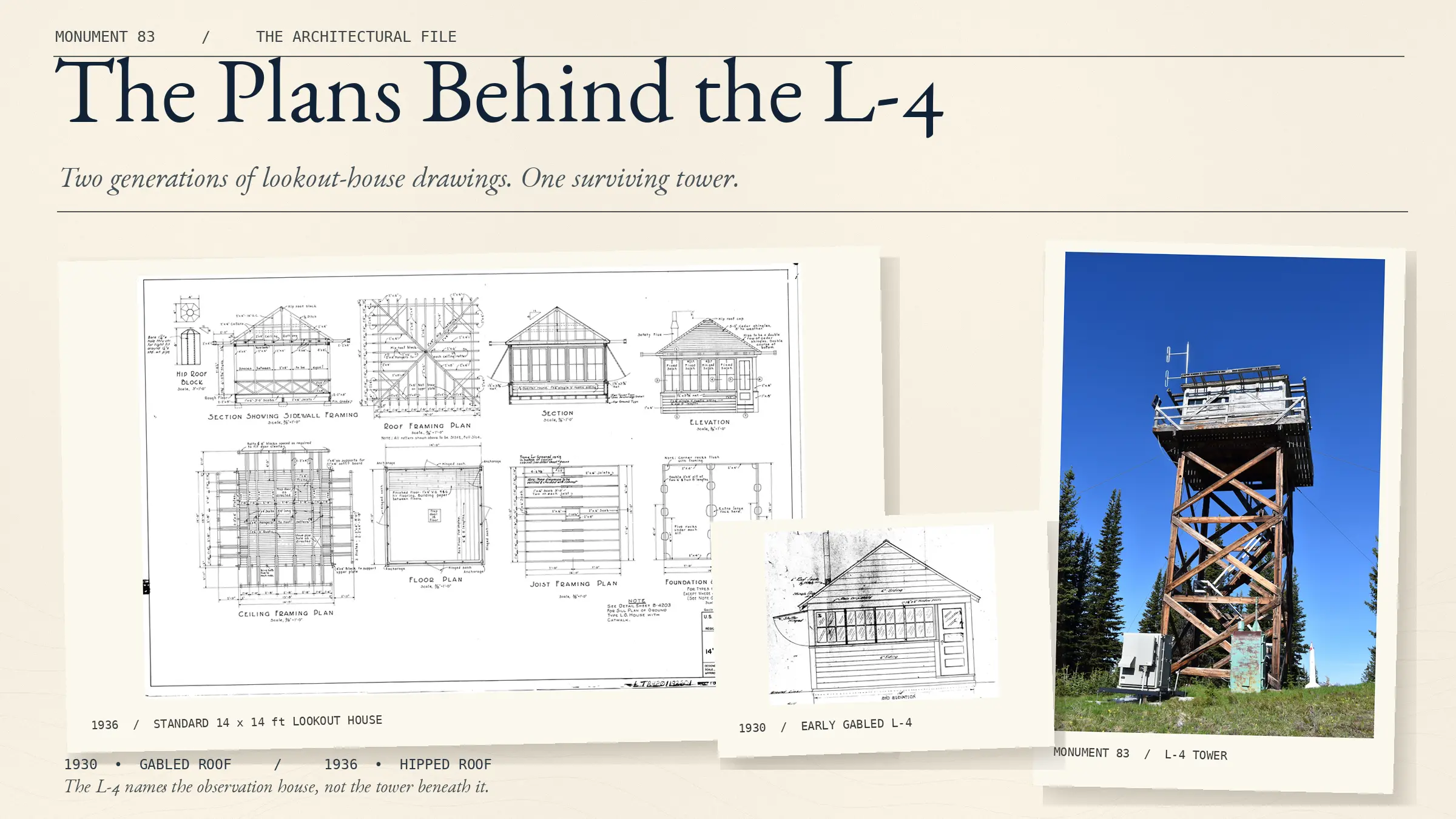
The name L-4 identifies the lookout house: a standardized observation room measuring fourteen feet square. It could be installed close to the ground or supported on a tower of a height selected for the location.
This distinction matters at Monument 83. The Canadian building of 1930 is a log cabin with its own small roof cupola, not a standard L-4. The American installation combines an L-4 house with a separate timber tower.
From a gable roof to a hipped roof
Forest Service drawings dated March 17, 1930, document an early L-4 house with a gabled roof. They include structural framing, glazed walls, protective shutters, materials schedules, and hardware specifications. The surviving bill of materials gives an unusual level of detail, down to the dimensions and quantities of lumber, nails, hinges, and roofing materials.
A later standardized L-4 variant, documented in a 1936 set of plans, uses the familiar hipped roof, sloping toward all four sides. It retains the fourteen-foot-square observation room and extensive windows. The drawings specify the surrounding catwalk, railings, trapdoor, anchorage, and structural connections.
The catwalk is approximately three feet wide, forming an overall platform about twenty feet square around the enclosed cab. Beyond offering access, the walkway helped with maintenance, examination of the immediate surroundings, and movement outside the enclosed room.
The engineering notes extend into the logistics of construction. Timber grades, inspection requirements, fabrication standards, component labels, hardware packages, and erection drawings all formed part of a system for sending workable building kits into remote territory.
The timber tower as a separate system
The Forest Service’s Standard Lookout Structure Plans of 1938 documents CT-3 timber-tower designs in three heights: twenty feet (drawing series L-11000), thirty feet (L-11100), and forty feet (L-11200).
The publication illustrates the structural family and identifies the thirty-foot drawings, but it does not reproduce the complete thirty-foot plan set used for a specific installation. Its longer-tower drawings reveal the general logic of diagonal bracing, timber connections, foundations, anchors, and assembly.
Monument 83’s reported thirty-foot height makes the CT-3 series a relevant comparison, not proof that any particular surviving drawing was used on Holdover Peak.
Plans and photographs serve different purposes
For reconstruction, the surviving tower photographs establish the actual appearance and arrangement of the Monument 83 structure. Period architectural plans help explain how comparable standardized elements were designed and assembled.
Where the two bodies of evidence agree, the reconstruction gains technical support. Where they differ or the specific historical record falls silent, the documented building must take precedence over the generic plan.
Another surviving plan provides an especially useful bridge between engineering and human activity. A December 1931 L-4 drawing titled Layout of Equipment specifies how the interior was arranged around a central fire finder. That document belongs to Chapter 7: once the building was assembled, its most important design problem was maintaining the observer’s field of view.
6. The Instruments of Fire Detection
A fire lookout was not merely a person with binoculars watching an impressive landscape. By the 1930s, lookout stations formed part of a coordinated system for detecting smoke, measuring directions, identifying locations, and communicating information to dispatchers and firefighters.
Two instruments developed by William B. Osborne are central to that story. Their names are similar, but their jobs were very different.
The Osborne Photo-Recording Transit created measured panoramic photographs. The Osborne Fire Finder helped an observer establish the direction of a suspected fire during daily operations.
A photographic instrument, not a souvenir camera
The Forest Service began developing a panoramic lookout survey program around 1930–1931. With the support of the Civilian Conservation Corps, substantial field photography began in 1933. The purpose was to produce seen-area maps: records showing which parts of a forest could actually be observed from particular stations and which areas were screened by ridges or terrain.
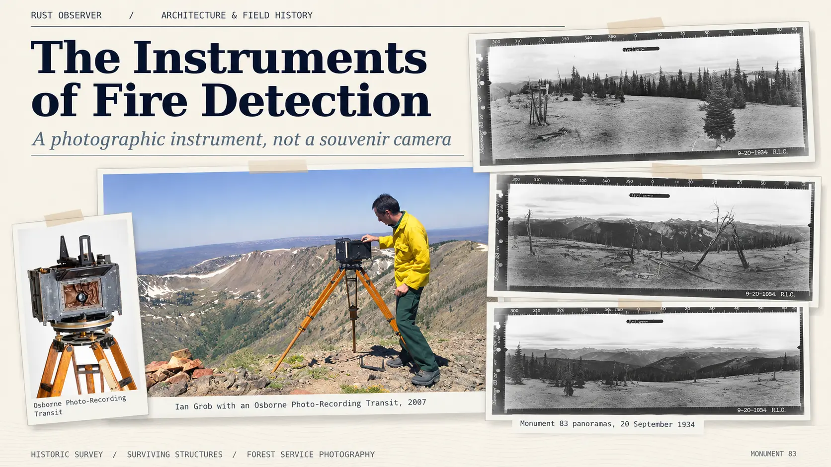
The Photo-Recording Transit combined a specialized panoramic camera with the angular scales of a surveying instrument. It weighed approximately seventy-five pounds (34 kilograms). Its film remained stationary while the lens rotated from right to left through an arc of 120 degrees. Three exposures covered the full 360-degree horizon.
The film recorded more than scenery. The horizontal border carried azimuth graduations, while vertical markings allowed angular elevations and depressions to be related to the horizon. Information about the station, date, and operator was incorporated into the photographic record.
The camera had to be transported to remote mountain stations and set up at a suitable observation position. Depending on the terrain and structures available, that might mean the ground, a lookout catwalk, a roof, or even another elevated support.
Sun position mattered. Photographers generally recorded the southwestern sector in the morning, the north around midday, and the southeast in the afternoon, reducing the difficulties posed by direct light.
The Forest Service also collaborated with Eastman Kodak on photographic materials intended to improve the visibility of distant terrain through haze and smoke. Infrared-sensitive and panchromatic films were both used during the broader program. The film type of each Monument 83 exposure has not been securely identified from the reproductions alone.
Robert L. Cooper at Monument 83, September 20, 1934
Three surviving panoramic photographs from Monument 83 are dated 9-20-1934 and signed R.L.C.
The initials identify Robert L. Cooper, a photographer in the Forest Service’s panoramic survey crew. Albert Arnst, who supervised the project, named R. L. Cooper among the six photographers employed to travel among lookout stations in the Pacific Northwest. The Monument 83 exposures preserve his initials on the original photographic borders.
The three sections cover:
- North, 300°–60°: the old tree-trunk observation platform, scattered conifers, and exposed summit terrain.
- Southeast, 60°–180°: distant ridgelines and the wide mountain panorama.
- Southwest, 180°–300°: numerous dead snags, fallen timber, and evidence of earlier forest disturbance.
Together, the views record both the lookout’s coverage and an extraordinary landscape snapshot. They document exactly the kind of territory that Forest Service planners needed to study when assessing where an observer could—or could not—see smoke.
The region’s own fire-control documentation reveals how those measurements could continue to be useful after the panoramas were taken. The Region 6 Fire Control Handbook (1943, in a surviving copy bearing later revisions) lists the vertical angle as one of the details needed to identify a reported fire on panoramic photographs. The camera records were not simply commemorative images filed away after a mountain visit. They could form part of the practical information used to locate a fire.
A second life for the Osborne camera
The instrument later gained a scientific role that its original operators could scarcely have anticipated.
In the 2000s, researchers used surviving Osborne cameras to repeat historical panoramas from comparable viewpoints. The paired images made it possible to examine changes in vegetation, forest cover, and the appearance of mountain landscapes across decades.
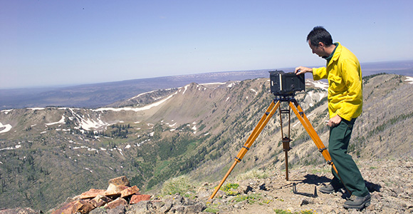
A photograph taken in 2007 shows U.S. Forest Service employee Ian Grob adjusting an Osborne Photo-Recording Transit during this work. The old camera still appears bulky and unmistakably mechanical; it remained useful because its method of recording a measured panorama could be reproduced.
The National Park Service has documented both the original photographic program and these modern rephotography efforts. Their significance lies in the combination of a carefully calibrated view and a known place from which it was taken.
The Osborne Fire Finder
The other Osborne instrument was intended for the working lookout itself.
The Osborne Fire Finder consists of a circular map and a rotating sighting mechanism with graduated horizontal bearings; versions also allow vertical-angle measurements. The map is oriented to the surrounding terrain so the observer can relate a distant smoke column to a direction from the station.
A lookout spots smoke, aligns the sight, and reads an azimuth. The observer then transmits the bearing to a dispatcher. If another lookout also sees the smoke, its bearing can be plotted against the first to produce an intersection and locate the suspected fire more precisely.
When a second observation is unavailable, local landmarks, estimated distance, a visible smoke base, and vertical-angle information can help narrow the location. The operator does not simply place a finger on a map and guess.
An important distinction emerges from the surviving plans. A December 1931 L-4 Layout of Equipment identifies a Blackfeet Fire Finder in the middle of the room. This does not make it an Osborne model. Different sighting instruments could occupy the same central operational position in comparable lookout buildings.
We have photographs of surviving Osborne Fire Finders at other locations, but no authenticated surviving photograph of the exact device formerly installed at Monument 83. The examples illustrate the operating principle without identifying an undocumented object.
The difference between the instruments is fundamental: the Photo-Recording Transit documented the view; the Fire Finder helped the operator report a fire within it.
7. Inside the L-4: A Room Designed for Observation
From outside, an L-4 appears to be a small wooden cabin lifted above the forest. Its interior tells a more exacting story. This fourteen-foot-square room had to function simultaneously as an observation station, workplace, and temporary residence.
The arrangement of its contents was governed by a simple operational priority: the observer needed to see the horizon.
The windows set the limits
At the centre of many lookout cabs stood the fire-finding instrument. To read the smoke’s direction, the operator needed to sight across the room and out through the surrounding windows. High furniture could obstruct that view.
This influenced the interior design. Cupboards, shelves, bunks, and work surfaces were commonly placed beneath the windows, while the area around the central instrument remained accessible. Folding furniture provided living space without permanently filling the observer’s working area.
The aim was to preserve useful sightlines, rather than enforce a universal rule that nothing at all could rise above the lower edge of a window. Structural posts, stove pipes, doors, and other unavoidable features sometimes interrupted the view. Period operating instructions even explained how to sight around certain obstructions.
We have not established a specific law requiring every interior object to remain below window height at all North American lookouts. What the evidence demonstrates is an architectural and operational design requirement: observation had priority over ordinary domestic furnishing.
The 1931 interior plan
A surviving L-4 plan, dated December 1931 and preserved within the set commonly filed as the 1932 L-4 drawings, includes a remarkable sheet titled Layout of Equipment.
It shows a central Blackfeet Fire Finder, a wood box and stove, shelves, a folding table, and two folding bunks. Several items are explicitly indicated in both their folded and deployed positions. The drawing is not a generic picture of a comfortable cabin. It is a working arrangement that accounts for where someone will stand, sleep, store supplies, and take measurements.
The plan belongs to the standardized L-4 design tradition; it is not an as-built inventory of Monument 83. Nonetheless, its logic is directly relevant to interpreting the surviving room.
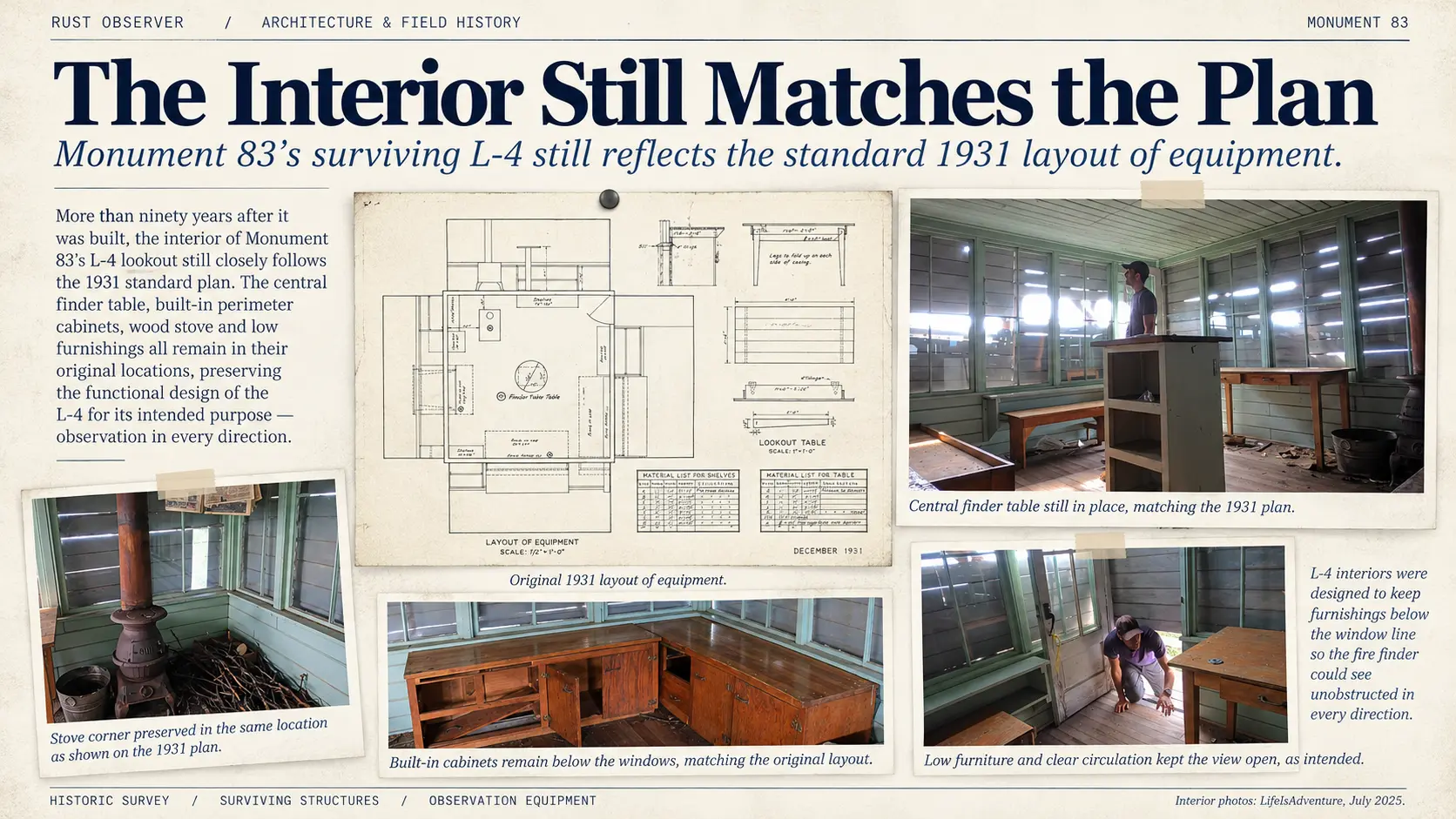
Monument 83, July 26, 2025
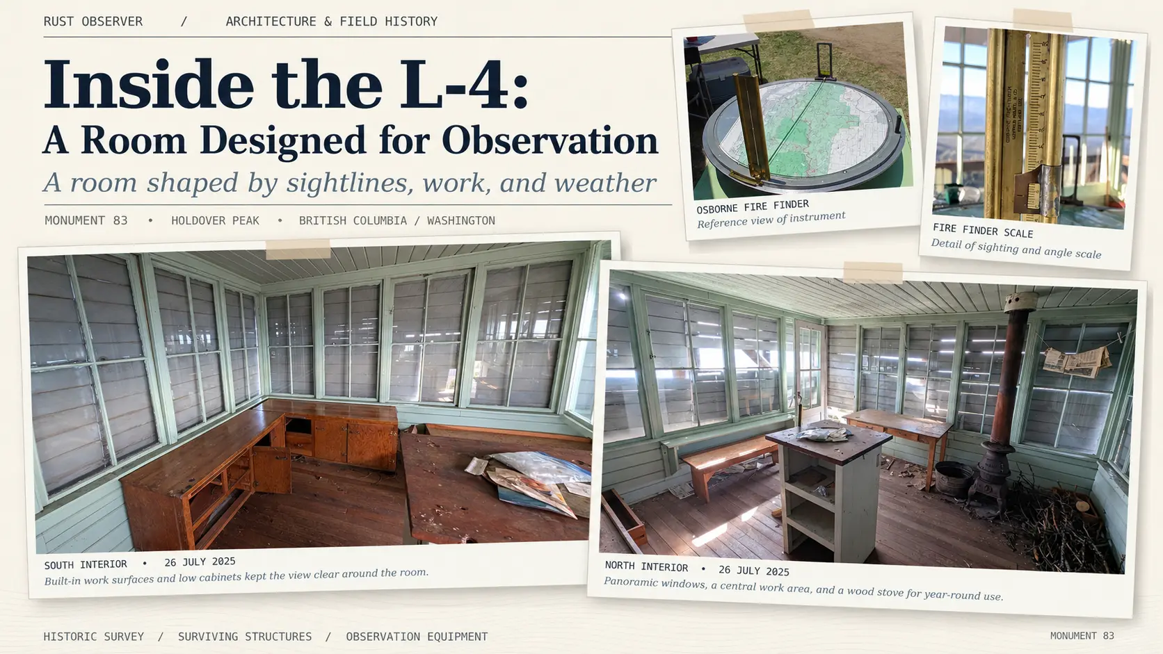
Two photographs taken on July 26, 2025, offer a detailed view of the American L-4’s surviving interior.
The south-side view records broad bands of glazing, wooden cabinets, and work surfaces beneath the windows. One upper surface bears holes and damage. They are worth documenting carefully because the room once required observation equipment, but the photographs alone do not establish whether the damage came from removal of a Fire Finder or from another alteration.
The north-side view reveals tables, a bench, additional storage, and the wood-burning stove with its flue passing through the ceiling. The stove was a practical necessity at a summit near 6,520 feet, where weather could become cold and windy even during the usual lookout season.
The furniture is low, the glazing extensive, and the central floor area relatively open. This relationship matches the operational priorities visible in the historical plans. It does not prove that each surviving piece occupies its original position.
The photographs do not show a Fire Finder installed in the room. Without additional mounting records, close-up evidence, or direct testimony, its former location should not be asserted more precisely than the surviving evidence allows.
A room that had to be lived in
A lookout observer might spend an entire season at a remote station. Beds, personal effects, cooking supplies, storage, records, communications equipment, and heat all competed for space within the observation room—or, depending on the station, in associated quarters.
The central question was not whether the occupant could furnish a pleasant mountain cabin. It was whether the room remained useful for detecting smoke while supporting the person who had to do that work day after day.
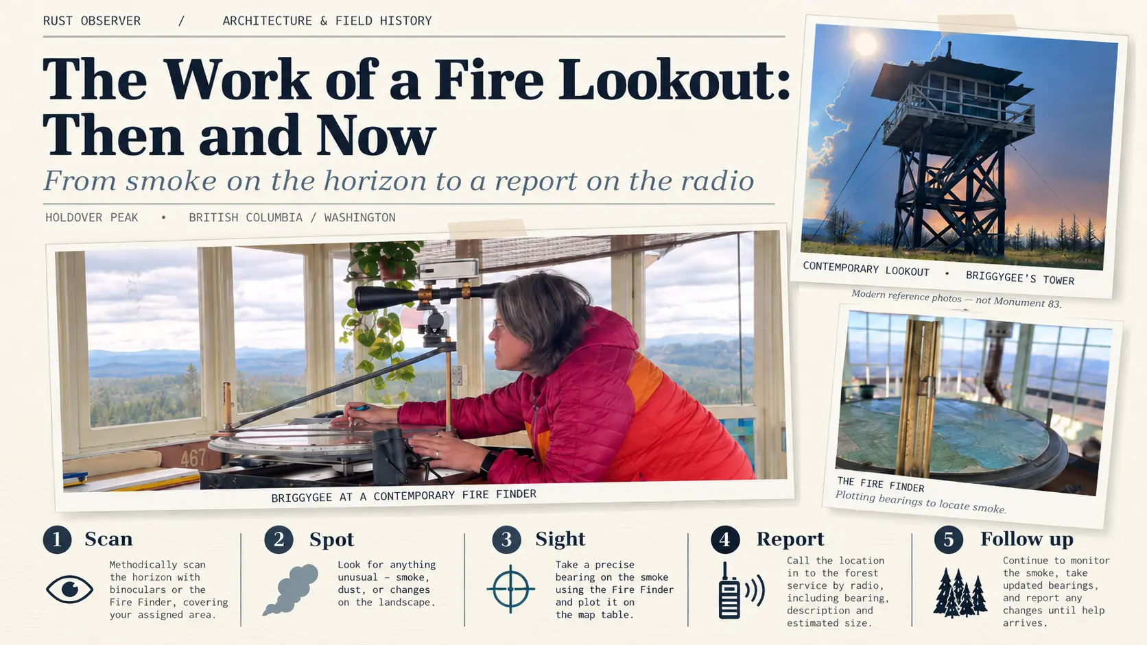
Contemporary images from working observer BriggyGee show that this relationship still matters. Her photographs place the Fire Finder, windows, furnishings, and personal equipment in the same working environment. These are modern stations, not images of Monument 83, but they clarify the logic behind the historical arrangements.
At Monument 83, the empty or damaged surfaces are part of the evidence. They show what survives after the daily equipment has been removed. The original plan explains how a comparable room was intended to operate. The two sources are more informative together than either would be alone.
The tower provided the height. The windows provided the view. The room was furnished to keep that view usable.
8. The Work of a Fire Lookout: Then and Now
Architecture and equipment reveal only part of a lookout’s purpose. The missing element is the work itself: a sequence of observation, measurement, communication, and follow-up carried out by a trained operator.
Fortunately, official manuals preserve much of that procedure. The Forest Service’s Region 6 Fire Control Handbook from 1943 documents the information used to locate fires in the Pacific Northwest. A California Region Fireman’s Guide from 1955 provides detailed instructions for preparing an initial lookout report. Modern lookout manuals and accounts from working observers show which underlying tasks remain familiar.
The examples below describe documented procedures from specified places and periods. They should not be read as proof that every detail was identical at Monument 83 in every decade.
Before smoke appeared
An observer’s responsibility began before the first suspicious plume appeared on the horizon.
The duty included maintaining a regular visual search, becoming familiar with terrain and landmarks, observing changing weather, maintaining communication with dispatch, and keeping records. The exact scan interval depended on the station and period; some modern U.S. volunteer lookouts describe systematic sweeps at approximately fifteen-minute intervals.
Familiarity mattered. Someone who knew the normal appearance of every ridge was better prepared to notice a slight change, distinguish a cloud or dust plume from smoke, and identify the nearest creek, slope, or drainage.
Weather monitoring was part of the same job. Wind direction, temperature, humidity, precipitation, and lightning all influenced the risk of ignition and the behavior of a developing fire.
Step one: recognize a possible smoke
A faint column becomes visible above a distant ridgeline.
The observer examines it, often with binoculars, and considers its appearance, persistence, location, and possible causes. Is it dust? A cloud? Smoke from a permitted fire? Is its base visible, or does it rise from behind a ridge?
The critical operational principle is speed. The Forest Service’s 1955 guidance instructs observers to notify dispatch promptly when uncertainty remains rather than risk missing an emerging fire. A potential false alarm is preferable to an undetected ignition that grows unchecked.
Step two: take a bearing
The observer turns the Fire Finder toward the smoke and sights along its line. The azimuth establishes the direction from the tower, measured in degrees.
If the base of the smoke can be seen, the vertical angle can provide additional information. The observer may also identify recognizable landmarks, estimate distance, and assess how the wind is carrying the column.
The readings form a technical report that another person can plot and interpret. An azimuth alone gives a direction, not a complete position: the reported fire could lie anywhere along that bearing until further information narrows the location.
Step three: report immediately
The 1955 Fireman’s Guide specifies an initial group of information for the Lookout Report, Form 265-R5: reporting station, azimuth, whether the smoke origin is visible, vertical angle when applicable, and location by local landmarks.
Those first details were to be transmitted promptly, leaving the radio or telephone circuit available for dispatchers to act. Other information—including fuel type, smoke volume, colour, character, and later observations—could follow.
The form illustrates a communications system designed to prioritize useful information when minutes might matter. The observer’s job was to give the dispatcher a location and an actionable description, not finish a lengthy report before making contact.
Step four: confirm the location
If another lookout could see the same smoke, its azimuth supplied an additional line of sight. Two bearings could intersect on a map; a third could help confirm the location or reveal an error.
Where triangulation was impossible, the dispatcher and observer relied more heavily on landmarks, topography, estimated distance, and the visible base of the smoke. The 1943 Region 6 handbook identifies vertical angles as useful for locating a reported fire on panoramic photographs—an explicit connection between the operational Fire Finder and the survey records made with the Photo-Recording Transit.
This was a coordinated process. The lookout measured and reported. Dispatch compared information and directed resources. Firefighters or smokechasers used the resulting location and descriptive clues to find the actual ignition on the ground.
Step five: continue observing
The first report did not necessarily end the observer’s involvement. Changes in smoke volume, colour, drift, or the appearance of flames could tell crews that conditions were evolving.
The lookout might relay information between dispatch and field crews, monitor weather changes, watch lightning-struck areas for delayed smoke, or confirm reports from other sources.
Documentation also mattered. Logs recorded observations, radio traffic, weather, and other events relevant to the station’s duties.
The modern observer’s perspective
A modern account from Alberta Wildfire describes many of these same operations: a Fire Finder oriented to true north, bearings reported to a fire centre, cross-shots from neighbouring lookouts, and quick action when a new smoke is spotted. Current Alberta guidance requires suspected wildfire activity to be reported rapidly, within five minutes of detection.
The continuation of these methods does not mean that every contemporary fire service uses the same reporting form or follows the same regional rules. The tools, communications systems, staffing arrangements, and response organizations vary.
This is where BriggyGee’s photographs and explanatory videos become valuable. They show the physical relationship between observer and instrument and provide a working person’s account of the routines that official manuals necessarily describe in formal language.
Rather than claiming her station operates exactly as Monument 83 did in 1937, we can use her published demonstrations to compare functions that have endured: scanning the surrounding country, operating the Fire Finder, living with the equipment, and communicating observations. Her perspective also creates an opportunity for a future interview about the less easily documented parts of the work: judgement, concentration, isolation, and experience.
The system behind the view
The lookout’s task was much more exacting than simply noticing smoke on the horizon. It depended on local knowledge, careful observation, calibrated equipment, clear communication, and the ability to make decisions under uncertainty.
This explains the architecture in the preceding chapters. The height of the tower, the size of the windows, the clear interior sightlines, the position of the Fire Finder, and the communications equipment were all designed to support a sequence of work.
The lookout detected a change in the landscape, measured it, reported it, and remained an observer while others acted.
9. Life at an Isolated Observation Station
The procedures explain how an observer worked. They do not fully describe what it meant to live at a remote post for an entire season.
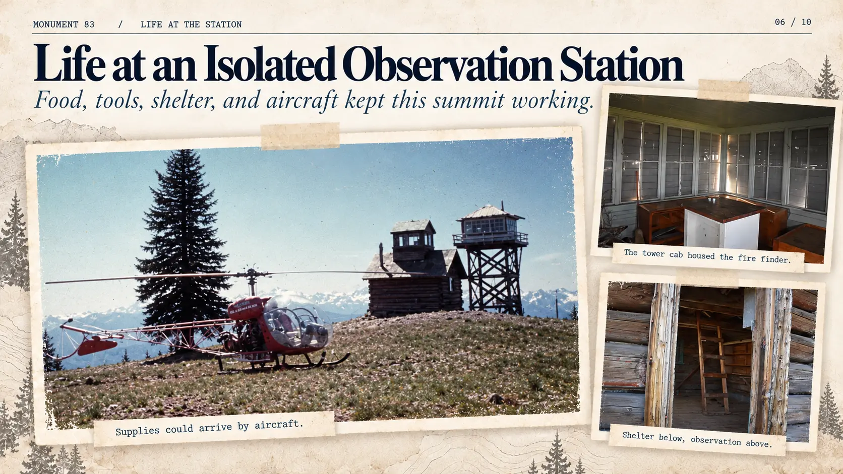
Monument 83’s location made the ordinary requirements of life unusually difficult. Food, water, communications, shelter, spare equipment, and supplies had to reach a summit far from normal roads and settlements. An observer could spend weeks there while weather, snow, and changing access conditions determined how often anyone else arrived.
From smoke detection to wartime aircraft warning
During the Second World War, Monument 83’s original lookout was used by the Aircraft Warning Service. Records place its activation on July 12, 1942, and deactivation on September 18, 1942, under the Seattle Filter Center.
The assignment used the same geographical advantage that had made the station useful for fire observation: a commanding view into the surrounding airspace and valleys.
The observers
A number of names have survived in newspapers and lookout histories.
Fred Vanderpool was stationed at Monument 83 in 1932. A. C. Mattison was the observer whose unusual cross-border position attracted newspaper attention in 1937.
In 1963, Jimmie Rea reached the region by aircraft from Winthrop to the remote Pasayten airstrip, then continued by horseback to Monument 83 with his supplies. He expected to complete his assignment before returning to college in the autumn.
These journeys demonstrate how a lookout’s isolation persisted even as the means of reaching the mountain changed.
Tom Parrish: two summers above the border
In 1968, recent Brewster High School graduate Tom Parrish spent the summer at Monument 83. A newspaper account reported that he left his post only once during the season, to visit a Canadian ranger station and receive a haircut. His parents visited by jeep, while his regular supplies arrived by airdrop.
Parrish returned in 1969. A newspaper article published July 31 reported that a helicopter had transported him to the lookout on the preceding Saturday, corresponding to July 26, 1969.
An authentic historical colour photograph shows a Bell 47-type helicopter at Monument 83, with both the Canadian log cabin and American L-4 tower behind it. The photograph has not been securely dated or linked to Parrish’s arrival. It nevertheless documents a real helicopter visit and provides a valuable view of the site during its operational years.
The photograph brings together old and new forms of technology: early-twentieth-century lookout architecture, an elevated observation station, and the helicopter that made remote logistical support more practical.
After the final watch
Regular staffed observation ended after the late 1960s, although sources describe occasional emergency use into the 1970s. The exact date of final closure remains uncertain.
The buildings outlived the profession practiced there. Their survival preserves the working arrangement of a small observation station long after its equipment and personnel have disappeared.
And between the two structures, the mountain retains an object that is not part of the official fire-detection system at all: a strange memorial with a name, a date, and a story that refuses to settle into a single explanation.
News from the Top: Monument 83 in the Newspapers
Long before hiking websites, satellite imagery and online videos, news from Monument 83 occasionally found its way into regional newspapers.
These reports offer a different perspective on the remote observation station: not just its architecture or fire detection duties, but the people, arrangements and occasional curiosities that made life on the international border unusual.
October 27, 1937 — A flag on the wrong side of the border
The Oregonian introduced A. C. Mattison, an American fire observer working from a lookout situated on Canadian soil.
The Canadian government had requested that the American flag not be flown from the building. The request was respected, but Mattison’s attempt to obtain a British flag apparently went unanswered.
According to the newspaper, the solution was a flagpole erected on the American side of the boundary. The reported height was an impressive 125 feet.
The same article offered a rather less diplomatic detail: local deer had become so comfortable around Mattison that one reportedly licked his face.
July 1, 1954 — The neighbours lend a hand
The Methow Valley News reported extensive cooperation between American and Canadian forest services.
Ranger Boyd and his Canadian crew had helped with the construction logistics of the new Monument 83 lookout. Materials were delivered to Manning Park, stored by Canadian personnel and transported toward the mountain, with Clyde Scott completing the final haul.
The article also reported that Canadian personnel had established radio communications with Monument 83 in 1953. Additional telephone connections were being considered in 1954.
Whatever complications the international boundary presented, the two forest services were clearly accustomed to working together.
July 11, 1963 — One observer, two countries
The Herald Reporter followed Jimmie Rea’s journey to his summer assignment.
After attending guard school, Rea travelled by aircraft from Winthrop to Pasayten Airport, then continued to Monument 83 on horseback with his supplies.
His assignment was particularly appropriate for the location: he would serve as a fire observer for both the United States and Canada.
The newspaper also noted his plans to return to college in September.
August 22, 1968 — A haircut across the border
Another Herald-Reporter article described the isolated summer assignment of Tom Parrish, a recent graduate of Brewster High School.
Parrish reportedly left his post only once that summer, visiting a Canadian ranger station, where he also received a haircut.
His parents managed a visit by jeep, while his regular supplies arrived by airdrop.
The newspaper identified his station as Monument 82, although its account the following year identified Parrish’s returning assignment as Monument 83.
July 31, 1969 — Returning by helicopter
The Herald-Reporter reported that Tom Parrish had returned to Monument 83 for another season.
This time, he arrived by helicopter.
He was expected to remain at the station until the beginning of the college term.
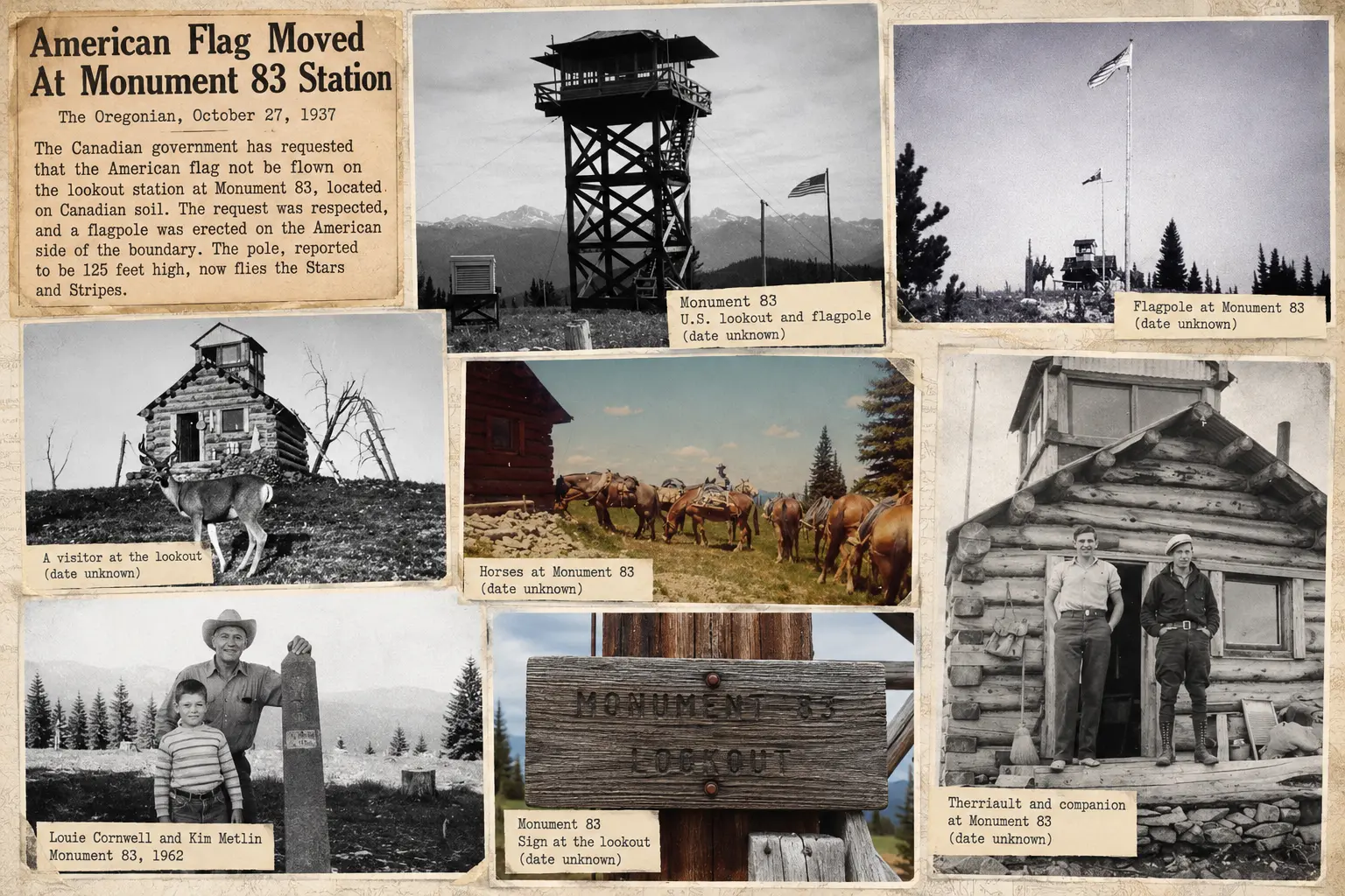
Taken together, these newspaper accounts tell a remarkably human story.
Monument 83 was a place where national flags required diplomatic consideration, construction materials crossed international boundaries with the help of neighbours, and young observers spent their summers watching over forests belonging to two countries.
Sometimes the news concerned international cooperation. Sometimes it concerned a helicopter, a friendly deer or a much-needed haircut.
Life at the top was rarely ordinary.
10. Pasayten Pete: Who—or What—Was He?
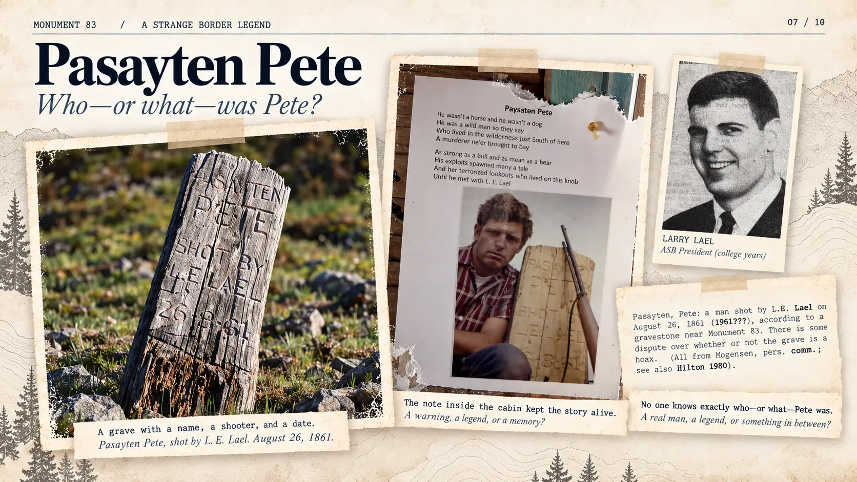
Between the old cabin and the L-4 tower stands one of the strangest artifacts at Monument 83: a weathered wooden marker resembling a small grave memorial.
Its inscription reads:
PASAYTEN PETE
SHOT BY L. E. LAEL
26-8-61
The marker supplies a victim, a person responsible, and an exact date. The obvious expectation is that a straightforward local story lies behind it.
Instead, the identity of Pasayten Pete remains unclear.
One marker, several explanations
Accounts collected by hikers, local historians, and fire lookout enthusiasts describe Pete as a hermit, a prospector, a rumrunner, a mysterious wild man—or a mule.
The mule explanation is especially practical. According to this story, Pete was an animal used for packing supplies. After breaking a leg, he reportedly had to be put down. The grave marker would then commemorate a difficult event while dressing it in the language of a human shooting.
Variations of the account appear on WillhiteWeb, TrailChick, in lookout-enthusiast histories, and in a September 2022 discussion on Backcountry Pilot.
Other descriptions are more theatrical. A hiking account raises the possibility of a rumrunner or dishonest prospector. Those versions transform an ordinary mountain death into something closer to a frontier crime.
A ballad inside the old cabin
Visitors to the 1930 cabin photographed a text titled Paysaten Pete, accompanied by an image of a man with a rifle standing beside a grave marker.
The ballad tells of a fearsome wild man haunting the country south of the lookout. Pete is presented as powerful and dangerous, troubling the men stationed on the mountain until an encounter with L. E. Lael provides the dramatic ending.
The text reads as a piece of local storytelling rather than a neutral official report. Its threatening character, heroic confrontation, and staged photograph make the episode deliberately memorable.
Yet this does not settle whether it was an invented joke about a mule, an embellishment of an older regional legend, or something else entirely.
The official history was uncertain too
In 1989, a historical study prepared for British Columbia’s Ministry of Parks, Natural and Human History Interpretive Theme Document for Manning Provincial Park, included an entry for Pasayten Pete.
The entry, on page 228, describes a man reportedly shot by L. E. Lael, then explicitly considers whether the grave could be a hoax.
Its date is revealing. The document prints August 26, 1861, followed by the authors’ own uncertain correction, “(1961???)”.
The marker itself gives only the abbreviated year “61.” As the surviving university records demonstrate, 1961 is the historically coherent date for the named Lael. The error shows how unstable the story had already become by the time historians attempted to record it.
The study attributes information to Faye Mogensen and directs readers to the recollections of Joe Hilton, a longtime regional trapper whose accounts were recorded in 1980 by park naturalists D. Gough and A. Midnight. That unpublished manuscript remains an important lead for anyone attempting to separate older local recollections from subsequent retellings.
The same study even questions the relationship between Pete’s name and Pasayten Creek. Was the creek named for Pete, or was Pete named after the creek? The authors could not establish the direction of that connection.
Larry E. Lael: a real person
The name on the marker is not entirely elusive. Eastern Washington College of Education newspapers document Larry E. Lael, an active student during the late 1950s and early 1960s.
He worked as a cartoonist for The Easterner, participated in campus activities, appeared in student organizational records, and held the rank of cadet colonel in the Reserve Officers’ Training Corps.
Those references establish that a man of this name was active in the region during the period indicated on the marker. They do not independently place him at Monument 83 on August 26, 1961.
Lael’s writing nevertheless supplies an unusual clue about his sense of humour.
On May 10, 1961, The Easterner published a letter he signed concerning a campus prank: someone had placed an old outhouse over a statue of Sacagawea. Another student had objected. Lael answered with elaborate mock seriousness, treating the unauthorized installation as evidence of imagination and technical effort.
His letter celebrated the anonymous prankster’s achievement while maintaining the form of a public argument. It reveals a taste for comedy that sounds strangely compatible with an outlandish memorial and ballad on a remote mountain.
The comparison is intriguing, not conclusive. The letter does not identify Lael as the prankster, and it does not prove that he wrote the ballad or fabricated Pete’s grave. But it gives us a documented person whose humour and theatrical framing fit the spirit of the story.
A legend that escaped the mountain
In 2016, author Allan Graybyrd published Pasayten Pete, a fantasy novel drawing on folklore associated with the northern Cascades. The book uses the mysterious figure as material for fiction; it is evidence of the legend’s cultural afterlife, not of the actual identity of the supposed victim.
What can be established is surprisingly limited. The marker exists. It names L. E. Lael and a date. A ballad and photograph dramatize the event. Regional accounts describe a mule or a mysterious human figure. A government-commissioned history recorded the uncertainty decades ago. A real Larry E. Lael appears in contemporary college archives.
Still missing is the decisive contemporary record: a lookout log, a firsthand account of the shooting, or documentation identifying precisely who—or what—was buried.
Monument 83 was a secluded workplace where observers spent long periods watching distant ridges, maintaining instruments, and living far from town. Such places also provided time for humour, storytelling, and the invention of legends.
Perhaps Pasayten Pete was a mule. Perhaps somebody borrowed an older story and turned it into an elaborate practical joke. Whatever happened, someone carved a marker, preserved a ballad, and gave visitors a mystery that has survived for decades.
The supposed shooter’s name leads to a documented person. The supposed victim remains the elusive one.
11. The Journey to Monument 83
After regular fire observation ended, Monument 83 acquired a different audience. Hikers, skiers, photographers, and historical researchers began approaching the same summit that once received a steady succession of observers and supply deliveries.
The modern route is part of the site’s character. Older service approaches changed with time, storm damage, and limited maintenance. A 2014 visit recorded a washed-out wooden bridge at Monument Creek, where travelers had to deal with a stream crossing that once carried a more dependable route.
The place remains isolated enough that weather and season make an enormous difference to how it is experienced.
From Remote Lookout to Hiking Destination
What once required a long journey for forest service personnel has become a documented backcountry hiking destination.
Monument 83 remains part of the recreational trail network of E.C. Manning Provincial Park, in British Columbia. Its historical significance, unusual position on the international border, and surviving lookout buildings continue to attract hikers, photographers and fire lookout enthusiasts.
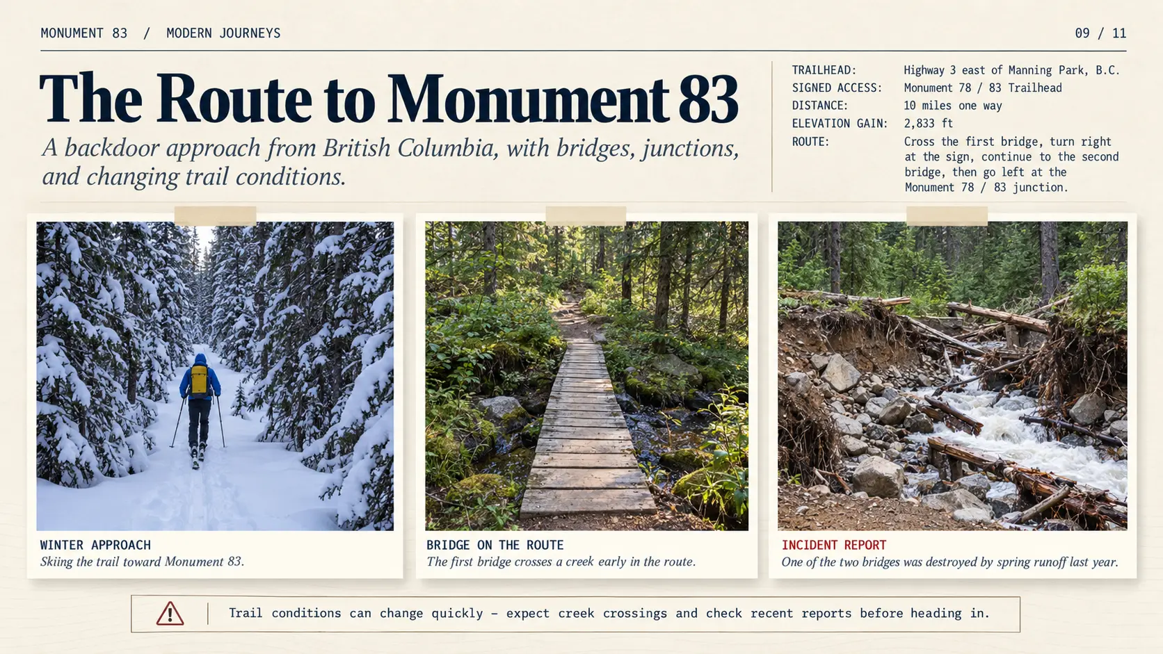
The Canadian approach begins at the Monument 78/83 trailhead, accessible from Highway 3 near Manning Park. Following an old service road, the route crosses forested valleys, streams and mountain slopes before climbing toward Holdover Peak.
The trail map shows a journey of approximately 30 kilometres round-trip. BC Parks lists the route at 16 kilometres one way, with approximately 850 metres of elevation gain. It is classified as a difficult hike, rather than a casual sightseeing excursion.
Visitors reaching the summit can see the original 1930 log cabin, the international boundary vista, the border monument and the American L-4 tower immediately across the boundary.
The route also offers a rare opportunity to experience the geography that made the observation station necessary: the surrounding forests, exposed mountain slopes and extensive views across the Cascades.
A Trail That Changes With the Seasons
The trail remains a wilderness route, where conditions can change considerably from year to year.
Historical accounts describe fallen trees, creek crossings and long stretches of isolated forest. Winter visitors have also approached the mountain on skis, encountering deep snow and very different conditions from those experienced by summer hikers.
A visitor incident report from 2025 documented a bridge destroyed by spring flooding, illustrating how quickly essential trail infrastructure can disappear.
Access should therefore never be assumed from an older trail map or hiking report. In its October 16, 2026 conditions report, BC Parks continued to list Monument 83 Trail as closed to the public because of construction work.
The international boundary adds another important consideration: reaching the Canadian side does not authorize visitors to cross into the United States to inspect the L-4 tower.
Monument 83 is no longer an active fire observation station, but its place in the landscape has not disappeared.
It has become a destination where visitors can encounter the remains of a working forest service installation, in the same mountain environment that once made it indispensable.
The winter summit
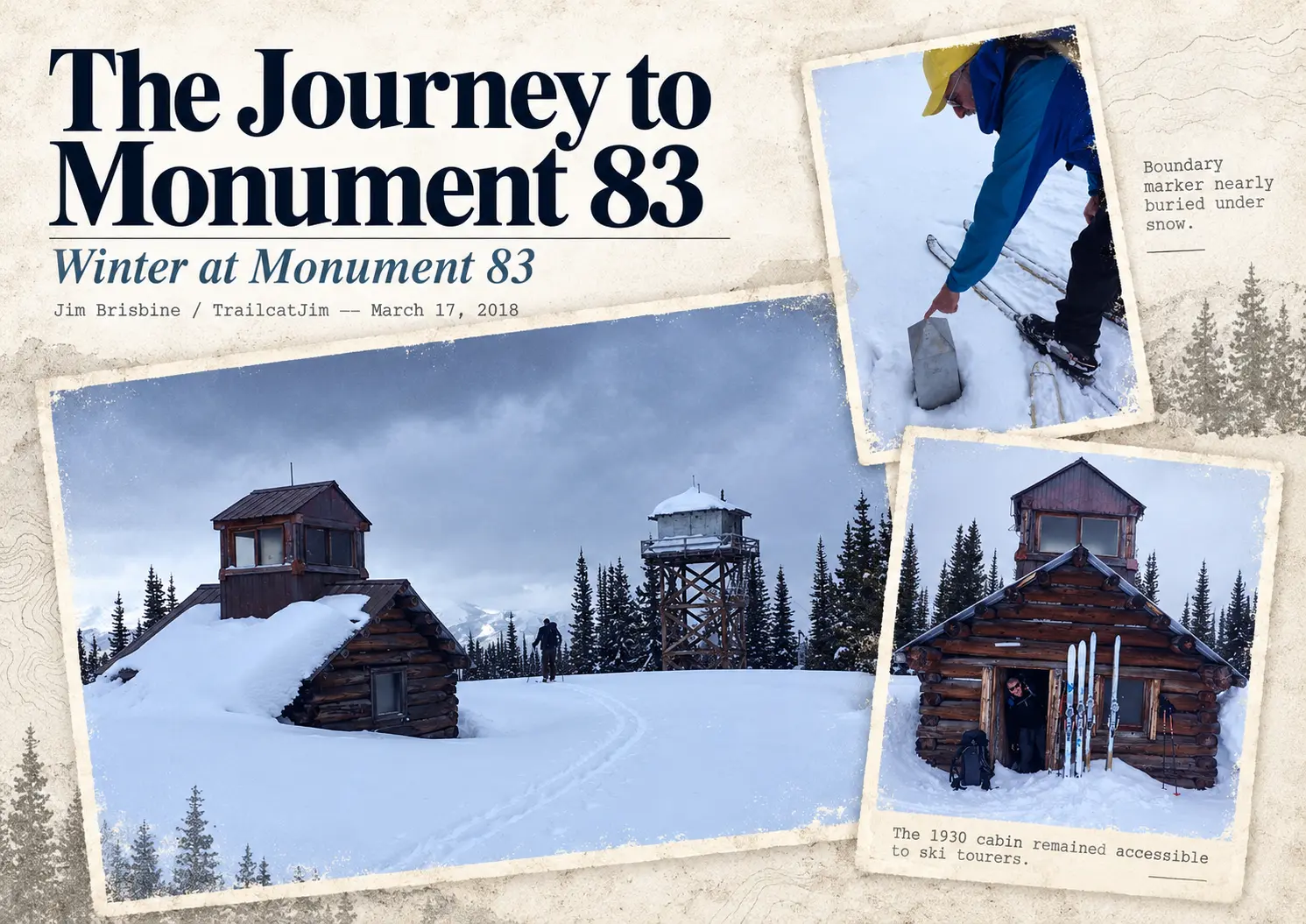
A ski journey documented by Jim Brisbine on March 17, 2018, presents Monument 83 under deep snow, with the 1930 cabin partly buried, the elevated L-4 rising over the surface, and the international boundary marker barely emerging from the snowpack.
The reported snow depth reached approximately 1.7 metres. The visitors briefly used the old cabin as shelter, demonstrating that the building could still provide practical refuge long after its working life had ended.
In these photographs, the border marker, tower, and historic cabin remain recognizable, but the topography of the summit is transformed. Snow reduces the visible height of objects that in summer seem fixed and prominent.
Reading the site in summer
TrailChick’s 2019 photographs show the same structures in clear weather, along with details that matter for reconstructing the historical site: the old cabin’s ladder toward its rooftop observation room, the extraordinarily close relationship between the tower and boundary marker, and the arrangement of the surviving buildings.
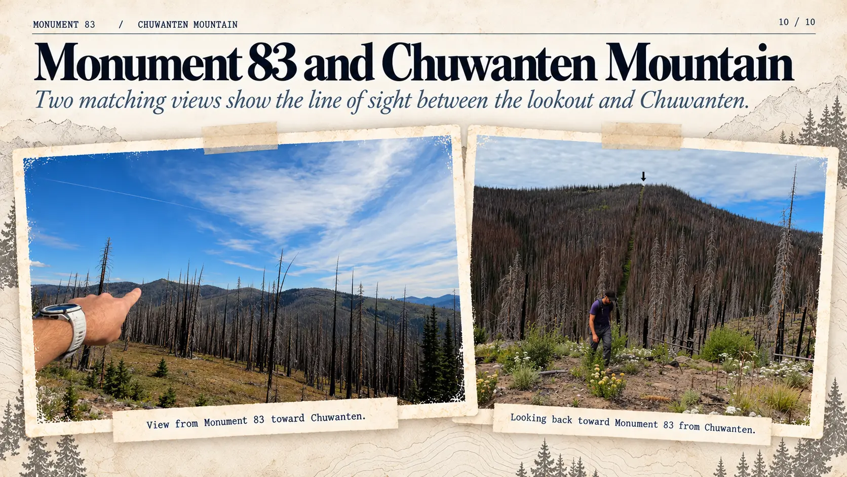
More recent video by Steve Amie also records the surrounding mountainous country, including the distant direction of Chuwanten Mountain and the altered appearance of some slopes following major fires.
These modern visitors do more than supply attractive photographs. Their records document access, condition, environmental change, and details of construction that no single historical plan captures.
There is an important difference between reaching a lookout and understanding it. The earlier visitors climbed the mountain to detect fire, relay reports, and live with the equipment. Today’s visitors arrive with cameras, maps, and an interest in the buildings themselves.
The terrain remains the same challenge. The reason for making the journey has changed.
12. When Fire Returned
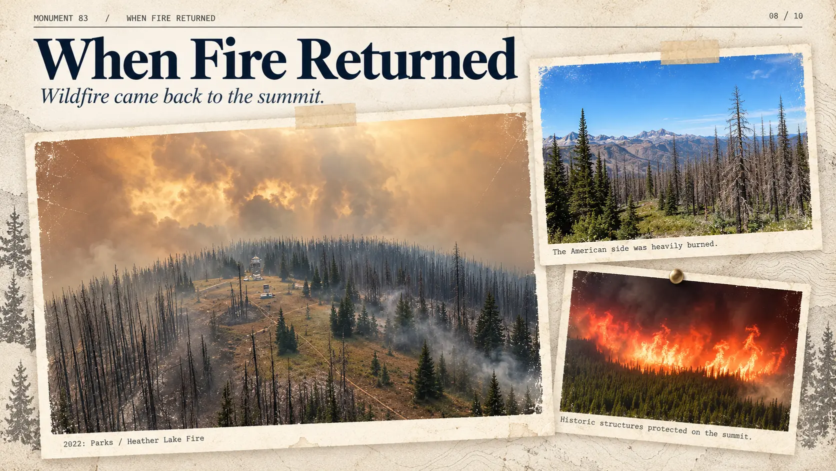
The station was established to detect wildfires. Decades after its active service ended, its own historic buildings became objects requiring protection from those same fires.
Two recent incidents illustrate the change, and it is important to distinguish them. They occurred four years apart and the protective photographs show different buildings.
September 2022: Parks / Heather Lake Fire
In September 2022, wildfire threatened the Monument 83 area from the American side of the border. The incident was known as the Parks Fire in Washington, while the portion burning in Canada was referred to as the Heather Lake Fire.
Canadian firefighting personnel undertook protective work at the historic installation. A photograph shared by the U.S. Forest Service, credited to the Manning Complex Incident Management Team, shows aluminized protective material around the lower part of the American L-4 tower.
The photograph does not show the complete tower wrapped from base to roof. That distinction matters when using the image to describe how crews attempted to protect the structure.
The surrounding mountains, meanwhile, carried visible evidence of active fire and damage. The summit’s lookout function had ended, but its value as a cultural landmark had not.
July 2026: Ptarmigan Fire
A separate fire was discovered in Washington’s Pasayten Wilderness on July 17, 2026. Official reporting identified the incident as the Ptarmigan Fire. Its initial detection involved both a member of the public and the active Goat Peak Lookout, followed by aircraft reconnaissance.
The incident affected terrain in the international border region, and fire crews carried out additional protection work on historic structures.
An official U.S. Forest Service photograph dated July 29, 2026, shows the old Canadian log cabin of 1930 wrapped in reflective, fire-resistant protective material.
This is not the same building as the tower protected in the 2022 photograph.
The two incidents show the practical consequence of preserving historic infrastructure in a fire-prone landscape. Lookout structures once intended to identify smoke early enough for crews to respond later required crews to return for their own survival.
The mountain has become a place where forest-fire history, changing vegetation, firefighting operations, and heritage protection are visible at once.
13. Monument 83 in Rust
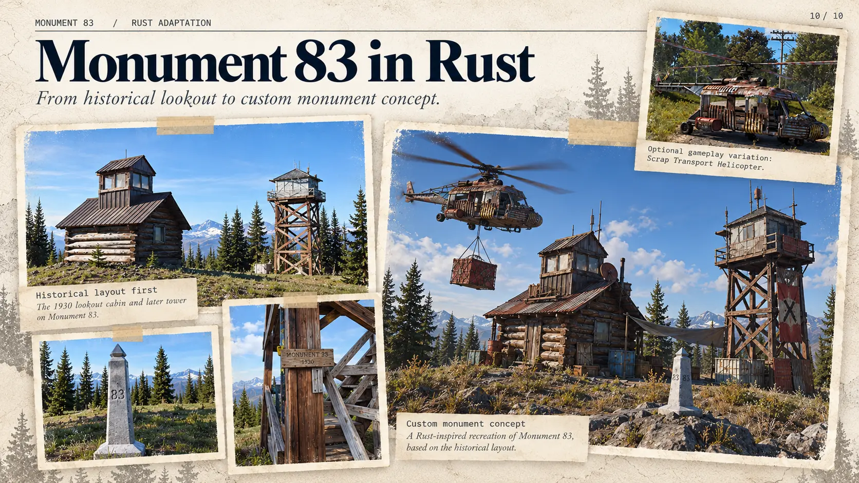
For Rust Observer, the attraction of Monument 83 is not simply that two unusual wooden buildings occupy a dramatic mountain summit. The site has a documented purpose, recognizable engineering, a complex boundary relationship, and a collection of physical details that can be compared with historical sources.
A faithful reconstruction begins with the real arrangement: three remnants of the original observation platform, the Canadian log cabin with its rooftop cupola, the U.S. L-4 house on its thirty-foot timber support, and the international boundary marker.
The topography and clearing matter as much as the buildings. The standard boundary vista is a narrow corridor across the landscape; the broad open summit is a separate historically modified area. Both help give the station its recognizable appearance.
The lookout’s interior also offers a design lesson. A central fire-finding station needs sightlines. Low furniture, windows, the stove, and limited floor space belong to the building’s function. They are not arbitrary decorations to scatter through a prefabricated room.
Original photographs establish visible architectural facts. Standard Forest Service drawings explain how comparable structures were designed. The two kinds of evidence should be used together without treating every historical drawing as a specific plan for Monument 83.
Historical reconstruction and gameplay are different layers
Once the documented buildings exist, Rust offers optional possibilities: inhabitable lookout rooms, communications equipment, radio relays, observation activities, and variations inspired by the site’s history of helicopter-supported supply and remote operations.
These additions can create useful gameplay. They should be presented as adaptations, not as previously undocumented features of the historic site.
An authentic L-4 observation cab does not need an invented maze of rooms to become interesting. Its dimensions, catwalk, stairs, windows, central working area, and physical relationship with the border already tell a story.
The same applies to the 1930 log cabin. Its low cupola belongs to an earlier stage of fire observation and to a landscape that was substantially more open in 1934. Rebuilding it without that context would miss the reason its architecture worked.
Monument 83 provides three generations of fire detection within a few metres of one another. That concentration of documented history is exactly what makes it valuable as a custom Rust monument.
A Century on the Border
The development of Monument 83 follows a remarkable progression: first a platform held up by three cut trunks, then a log cabin with a glass-walled cupola, and finally an elevated L-4 observation house on an engineered timber tower.
Each stage addressed the same problem: how to detect smoke early enough to send help into a vast and difficult mountain landscape.
The photographic equipment documented the station’s views. The Fire Finder converted a visible plume into a useful bearing. The room’s arrangement kept the sightlines clear. The observer turned measurement into communication and action.
The border added an unusual administrative dimension. The first permanent American-operated cabin stood in Canada; the successor tower stood just across the line in the United States. Canadian personnel helped with construction and communications. The surrounding forest, of course, never paused at the international marker.
Later, the buildings ceased to serve as active lookout stations. Visitors arrived for their history, their architecture, and the odd legend of Pasayten Pete. Wildfire eventually returned, this time threatening the lookouts themselves.
What survives is more than a pair of picturesque towers. Monument 83 preserves a physical explanation of how an isolated observation system was designed, operated, and inhabited—and why people on both sides of a border considered the view from this summit worth protecting.
Historical Sources and Documentation
Site, architecture, border, and observers
- Canadian Register of Historic Places / BC Parks. Monument 83 — Statement of Significance. Official heritage assessment of the Canadian log cabin, cleared landscape, and relationship with the border.
- WillhiteWeb. Monument 83 Lookout (Holdover Peak). Site history, 1934 panoramas, observer accounts, historic photographs, and excerpts from contemporary newspapers.
- Methow Valley Forest Fire Lookout Association. Monument 83. Historical chronology and construction references.
- Washington Forest Lookouts. Monument 83. Archival newspaper clippings, aircraft warning dates, accounts of the observers, and photographs.
- International Boundary Commission. The Boundary. Official international boundary maintenance and the standard boundary vista.
- U.S. Department of Agriculture, Forest Service (1930). Lookout House — Plan L-4, 1930 drawings (PDF). Early gabled L-4 building and materials specifications.
- U.S. Department of Agriculture, Forest Service (December 1931). L-4 Lookout House — Layout of Equipment, sheet 5 of 7 (PDF). Standardized interior with Blackfeet Fire Finder, folding bunks, table, shelves, and stove.
- U.S. Department of Agriculture, Forest Service, Region 6 (1936). Standard 14 × 14 ft L-4 Lookout House (PDF). Hipped-roof L-4 design, glazing, catwalk, and framing.
- U.S. Department of Agriculture, Forest Service (1938). Standard Lookout Structure Plans. CT-3 timber tower drawing families, including the 20-, 30-, and 40-foot variants. See archival plans cited in the previously published article.
Instruments, photography, and fire detection procedures
- National Park Service. History of the Panoramic Lookout Project. Forest Service panoramic surveys, the Osborne Photo-Recording Transit, camera mechanics, survey objectives, and film types.
- National Park Service. 50 Nifty Finds #24: Fire Away!. Albert Arnst’s photographic team, including Robert L. Cooper, and the early survey program.
- National Park Service. Historic Transportation Planning Project — Albert Arnst’s account. First-person program history, crew roster including R. L. Cooper, and the connection between panorama surveys and fire-detection mapping.
- National Park Service (2020). Walking in the Steps of History: Retaking Panoramic Lookout Photographs. Ian Grob’s work with a surviving camera; accompanying field photograph identified in the original image record as 2007.
- Wallowa Resources. Explore the Osborne Panoramas. Historical panorama equipment, film, camera markings, and technical context.
- U.S. Forest Service, Region 6 (1943). Fire Control Handbook — Record Information for Finding Fire. Lookout reporting, azimuths, vertical angles, panoramic photographs, and information sent to smokechasers.
- U.S. Forest Service, California Region (1955). Fireman’s Guide — Lookout duties and Form 265-R5 (reproduced excerpt). Historical reporting sequence, fire-finder readings, and initial radio or telephone communication.
- U.S. Forest Service. Fire Lookouts (PDF). Operational role, equipment, weather observation, and triangulation.
- Forest Fire Lookout Association, San Diego–Riverside Chapter. A Lookout’s Day in the Tower. An example of contemporary station routine and scanning practice.
- Alberta Wildfire (2016). Firefighter in the Field: An Office in the Sky. First-person description of Fire Finder bearings, triangulation, weather, and smoke reporting.
- Alberta Government. How We Fight Wildfires. Contemporary responsibilities and reporting expectations for provincial lookout observers.
- BriggyGee. Official media links. Modern working-lookout photographs and videos; source of contemporary visual comparison, not evidence of Monument 83’s historical staffing or equipment.
- National Park Service. Ian Grob operating the Osborne camera — original photograph. Photograph dated 2007 in supplied archival information.
- Monument 83 visitor photographs (July 26, 2025). Contemporary L-4 interior photographs, south and north sides.
Steve Amie / Life is Adventure
- Amie, Steve (2025). Monument 83. Life is Adventure. Field documentation of the historic fire lookout station at Holdover Peak, British Columbia, including access through E.C. Manning Provincial Park and a video exploration of the surviving structures.
https://steveamie.com/monument-83/ - Life is Adventure — Steve Amie. Monument 83 + Chuwanten Mountain (BC, Similkameen). YouTube. Video exploration documenting the approaches, exterior architecture and surviving interiors of the historic lookout buildings at Monument 83. An important contemporary visual reference for comparison with the original L-4 architectural drawings.
https://www.youtube.com/watch?v=QEgtlVgYu74 - Amie, Steve (2024). US / Canada Border Monuments. Life is Adventure. An illustrated overview of numbered boundary monuments, including Monument 83, and the maintained clearing along the international boundary.
https://steveamie.com/us-canada-border-monuments/
Historical fires, folklore, and modern visitors
- George R. Fahnestock (1974). Fires, Fuels, and Flora as Factors in Wilderness Management: The Pasayten Case (PDF). Regional history of wildfire, including major Pasayten fires in 1926 and 1929.
- Fraser, David F., et al. (1989). Natural and Human History Interpretive Theme Document for Manning Provincial Park (PDF). See pp. 228 and 237 for Pasayten Pete, the grave marker, and the uncertainty recorded by park historians.
- Eastern Washington College of Education. The Easterner student newspaper, especially the May 10, 1961 Larry E. Lael letter about the Sacagawea statue incident.
- Backcountry Pilot (September 2022). Pasayten airstrip discussion, including the mule explanation and a version of the cabin ballad.
- Graybyrd, Allan (2016). Pasayten Pete. Fantasy fiction inspired by the regional legend; a cultural reference, not historical proof.
- TrailChick (2019). Monument 83 Lookout. Site photographs, surviving buildings, and architectural details.
- TrailCatJim / Jim Brisbine (March 17, 2018). Monument 83 Lookout Ski Tour. Winter access, snow cover, and use of the original cabin as temporary shelter.
- Steve Amie. Monument 83. Contemporary exploration and landscape views.
- U.S. Forest Service / Manning Complex Incident Management Team (September 2022). Monument 83 fire protection photograph, showing protective wrapping around the lower portion of the American L-4 tower.
- U.S. Forest Service (July 29, 2026). Official photograph of the Canadian 1930 log cabin wrapped for protection during the Ptarmigan Fire.
Visiting Monument 83
- BC Parks. E.C. Manning Provincial Park. Official park information, recreational access, hiking routes, trail conditions and visitor guidance.
https://bcparks.ca/ec-manning-park/ - Willhite, Robert. Monument 83 Lookout (Holdover Peak). Historical documentation of the lookout station, including detailed hiking directions from the Canadian side, distances, elevation gain and surviving structures.
https://www.willhiteweb.com/washington_fire_lookouts/monument_83_lookout/international_border_247.htm - AllTrails. Monument 83 Trail — British Columbia, Canada. Recreational trail map, elevation profile, photographs and visitor reports documenting contemporary hiking access and trail conditions.
https://www.alltrails.com/trail/canada/british-columbia/monument-83-trail - BC Parks (October 16, 2026). E.C. Manning Provincial Park — Trail Conditions Report. Official trail status report identifying the Monument 83 Trail as closed to public access due to construction work at the time of publication.
https://nrs.objectstore.gov.bc.ca/kuwyyf/ec_manning_trail_report_bacddd5a9c.pdf?d=20261016